Nail Biter Storm 1/24 - 1/26/23
-
tron777

- Major Hurricane
- Posts: 25376
- Joined: Fri Feb 26, 2021 5:10 pm
- Location: Burlington, KY
- Contact:
Re: Nail Biter Storm 1/24 - 1/26/23
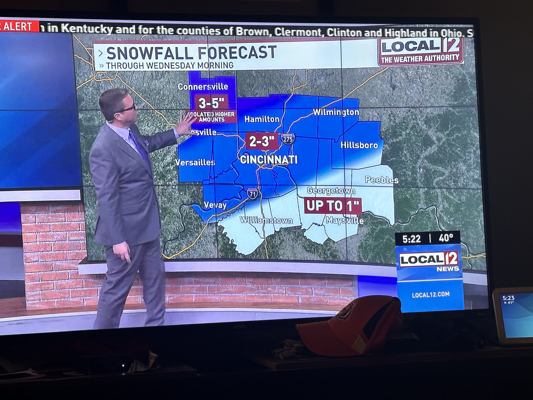
18Z NAM is an all out screw job for NKY and Cincinnati / Hamilton Co. This is valid thru late tomorrow morning.  Really shocked that ILN did not change things all that much. I was 2-4" now they have me at 1-3". Still 4-6" 20 mins to my West in Lawrenceburg (Dearborn Co). Good luck ILN! Would love for their forecast to be correct for all locations.
You do not have the required permissions to view the files attached to this post.


Re: Nail Biter Storm 1/24 - 1/26/23
So my wrongful post earlier was spot ontron777 wrote: ↑Tue Jan 24, 2023 3:53 pm 18Z NAM is an all out screw job for NKY and Cincinnati / Hamilton Co. This is valid thru late tomorrow morning.
NAM.png


Silverton, OH
Co-Owner of Ohio Valley Weather Center LLC
https://www.facebook.com/ovwcllc
Co-Owner of Ohio Valley Weather Center LLC
https://www.facebook.com/ovwcllc
Re: Nail Biter Storm 1/24 - 1/26/23
Les the nam did a horrible job this past weekend with precip type. Maybe they are just booting that model and going with some of the others. I have no ideal if they blend the models or use one in different situation. I do like the call of 1-3 and that still seems reasonable imo. Probably leaning towards the lower end but still believe 3 inches could happen locally in northern ky if everything pans out timing wise. BTW 43 is my high for today so the NWS did a nice job with temps. Matter of fact Indy was higher today because they had less snow on the ground.
-
tron777
- Major Hurricane
- Posts: 25376
- Joined: Fri Feb 26, 2021 5:10 pm
- Location: Burlington, KY
- Contact:
Re: Nail Biter Storm 1/24 - 1/26/23
Unfortunately yes.Trevor wrote: ↑Tue Jan 24, 2023 3:59 pmSo my wrongful post earlier was spot ontron777 wrote: ↑Tue Jan 24, 2023 3:53 pm 18Z NAM is an all out screw job for NKY and Cincinnati / Hamilton Co. This is valid thru late tomorrow morning.
NAM.png
Re: Nail Biter Storm 1/24 - 1/26/23
Nostradomus is in the house!!!Trevor wrote: ↑Tue Jan 24, 2023 3:59 pmSo my wrongful post earlier was spot ontron777 wrote: ↑Tue Jan 24, 2023 3:53 pm 18Z NAM is an all out screw job for NKY and Cincinnati / Hamilton Co. This is valid thru late tomorrow morning.
NAM.png
-
tron777
- Major Hurricane
- Posts: 25376
- Joined: Fri Feb 26, 2021 5:10 pm
- Location: Burlington, KY
- Contact:
Re: Nail Biter Storm 1/24 - 1/26/23
Same here for my high Tim. CVG's back down to 39 now thanks to clouds rolling in ahead of the storm. We'll just have to wait and see what happens. I've looked at too much data so my head is spinning!tpweather wrote: ↑Tue Jan 24, 2023 4:01 pm Les the nam did a horrible job this past weekend with precip type. Maybe they are just booting that model and going with some of the others. I have no ideal if they blend the models or use one in different situation. I do like the call of 1-3 and that still seems reasonable imo. Probably leaning towards the lower end but still believe 3 inches could happen locally in northern ky if everything pans out timing wise. BTW 43 is my high for today so the NWS did a nice job with temps. Matter of fact Indy was higher today because they had less snow on the ground.
Re: Nail Biter Storm 1/24 - 1/26/23
Les the reason I kept the 3 inch total in as the rate still looks to be rather high so even a few hours of snow can add up quickly before a changeover. I have come down on the sleet and though we may see a brief period but I believe more than likely a snow to rain situation.tron777 wrote: ↑Tue Jan 24, 2023 4:06 pmSame here for my high Tim. CVG's back down to 39 now thanks to clouds rolling in ahead of the storm. We'll just have to wait and see what happens. I've looked at too much data so my head is spinning!tpweather wrote: ↑Tue Jan 24, 2023 4:01 pm Les the nam did a horrible job this past weekend with precip type. Maybe they are just booting that model and going with some of the others. I have no ideal if they blend the models or use one in different situation. I do like the call of 1-3 and that still seems reasonable imo. Probably leaning towards the lower end but still believe 3 inches could happen locally in northern ky if everything pans out timing wise. BTW 43 is my high for today so the NWS did a nice job with temps. Matter of fact Indy was higher today because they had less snow on the ground.Seriously though, if we can muster 3" I'd be tickled to death. Expecting an inch or two but would be thrilled to hit the higher end of the range.
Re: Nail Biter Storm 1/24 - 1/26/23
Roll with the hrrr model until it blows a forecast. Again we have seen in past years where models can outperform other models for a period of time. Maybe the hrrr model is better when you have dynamic cooling. I don't have the answer but let it roll tonight and if it performs well then we need to remember that when this type of situation happens again.
-
tron777
- Major Hurricane
- Posts: 25376
- Joined: Fri Feb 26, 2021 5:10 pm
- Location: Burlington, KY
- Contact:
Re: Nail Biter Storm 1/24 - 1/26/23
From the boys:
.NEAR TERM /UNTIL 6 AM WEDNESDAY MORNING/...
An energetic system will be entering the region from the
southwest late this evening and quickly spreads northeast
between midnight and 02:00, with a focus to the northwest of the
I-71 corridor. Temperatures will be nearly steady after this
evening as significant cloud cover precedes the precipitation.
A very fine line exists where the snow/rain line evolves
tonight. Through 04:00, the models suggest that northern
Kentucky west of Maysville will see snow, mixed with rain, then
changing to rain. In metro Cincy and areas west, precip could
briefly start as a mix but then quickly change to snow. After
daybreak, this area will change to rain with a brief overlapping
of a wintery mix. A similar timing is in store for most of the
CWA with a changeover to rain after daybreak given a strong push
of warm southerly air ahead of the low over IN.
Snowfall rates along a narrow sw-ne oriented band will likely be
>1"/hr, though the exact placement of this feature still has a
good bit of uncertainty.
With the warm temperatures, the tradeoff over the southern 1/3
of the CWA is going to be where the heavy band sets up and when
the warm air switches to rain.
&&
.SHORT TERM /6 AM WEDNESDAY MORNING THROUGH WEDNESDAY NIGHT/...
As the low tracks through northwest CWA, a mix is most likely
to occur later in the day between 15:00 and 18:00. Wind gusts
tomorrow in the warm air are likely to be in the 20-30 mph
range, up to 35 mph along and southeast of the I-70 corridor.
A little later in the morning, a dry punch is expected to
scatter out the rain and substantially limit precip amounts
southeast of the I-71 corridor. Scattered showers will still be
possible but the prevailing moderate precipitation will have
ended not terribly long after daybreak.
Temperatures will only rise slightly in the northwest from the
low to mid 30s, while the southeast could be warmer than this
by 20 degrees - in the mid 50s.
Late in the day, the surface low heads to Lake Erie trailing a
cold front that lingers from about Ripley County IN, through
Dayton, to Bucyrus. This keeps the threat of snow a little more
to the west during the day. In the evening, the cold front
makes an eastward progression and changes leftover shower
activity back to snow for the rest of the CWA by midnight.
Overnight Wednesday,these showers will bring an additional inch
of accumulation to northern CWA, about a half inch or less for
Kentucky and south central Ohio.
Overnight lows will drop to the lower 30s as the surface wind
remains more westerly, which does not permit any significantly
colder air to be pulled into the region.
Re: Nail Biter Storm 1/24 - 1/26/23
Well, my teacher friends were hoping for a snow day, but that's not going to happen in Grant County. Oh well, maybe we will cash in another time.
-
tron777
- Major Hurricane
- Posts: 25376
- Joined: Fri Feb 26, 2021 5:10 pm
- Location: Burlington, KY
- Contact:
Re: Nail Biter Storm 1/24 - 1/26/23
12Z Euro is finally starting to come in. It has the low from Land Between the Lakes in SW KY at 1000 MB to Cincy at 997 MB to Cleveland still at 997 MB. Much less precip too. From midnight to 6am it's only giving Cincy 0.20" Your heaviest QPF is from IND to NW of the Dayton Metro probably up towards Eric there in Greenville but that is only like 0.50" We'll see how it all shakes out.
-
tron777
- Major Hurricane
- Posts: 25376
- Joined: Fri Feb 26, 2021 5:10 pm
- Location: Burlington, KY
- Contact:
Re: Nail Biter Storm 1/24 - 1/26/23
I could see a delay here in Boone Co but no reason to close the entire day either IMO.
-
mainevilleweather
- Thunder Storm
- Posts: 248
- Joined: Sat Jan 08, 2022 11:11 am
Re: Nail Biter Storm 1/24 - 1/26/23
Well the Euro just dropped me from 7 inches on the earlier run to 2. So there is that haha.
Re: Nail Biter Storm 1/24 - 1/26/23
39 degrees here in Somerville and cloudy
Re: Nail Biter Storm 1/24 - 1/26/23
Interesting question! But that’s far too mesoscale to affect the modeling output. But I like your line of thinking there!tpweather wrote: ↑Tue Jan 24, 2023 3:47 pm Quick question for the folks well above my pay level? When I saw the big pressure drop near Houston a thunderstorm with a possible tornado was nearby. Does this cause a bigger pressure change for a brief period and then it returns to what the output was showing before. I have no clue on this because the pressures are starting to go down further northeast but seem to be falling back into that 1000- 1004 area.


Or maybe it sounds like you weren’t referring to it affecting modeling. Apologies if I misread.
Silverton, OH
Co-Owner of Ohio Valley Weather Center LLC
https://www.facebook.com/ovwcllc
Co-Owner of Ohio Valley Weather Center LLC
https://www.facebook.com/ovwcllc
Re: Nail Biter Storm 1/24 - 1/26/23
I am down to 42 degrees from a high of just shy of 45. I am looking forward to seeing the trends of the storm. I can see this is going to be a make or break storm but there are more chances for snow in the future!!!
Re: Nail Biter Storm 1/24 - 1/26/23
40° here with a dewpoint of 31°. I just love my new weather station!! Thank you wife!!!
Constant Lurker, Occasional Poster
Miami Township Southern Montgomery County
Miami Township Southern Montgomery County
-
tron777
- Major Hurricane
- Posts: 25376
- Joined: Fri Feb 26, 2021 5:10 pm
- Location: Burlington, KY
- Contact:
Re: Nail Biter Storm 1/24 - 1/26/23
I'll chime in on this too... Tim, are you referring to the SPC Meso Page on this?Trevor wrote: ↑Tue Jan 24, 2023 4:35 pmInteresting question! But that’s far too mesoscale to affect the modeling output. But I like your line of thinking there!tpweather wrote: ↑Tue Jan 24, 2023 3:47 pm Quick question for the folks well above my pay level? When I saw the big pressure drop near Houston a thunderstorm with a possible tornado was nearby. Does this cause a bigger pressure change for a brief period and then it returns to what the output was showing before. I have no clue on this because the pressures are starting to go down further northeast but seem to be falling back into that 1000- 1004 area.
Or maybe it sounds like you weren’t referring to it affecting modeling. Apologies if I misread.
-
tron777
- Major Hurricane
- Posts: 25376
- Joined: Fri Feb 26, 2021 5:10 pm
- Location: Burlington, KY
- Contact:
Re: Nail Biter Storm 1/24 - 1/26/23
What kind did she get? Davis Vantage Vue or something else?
-
MJSun

- Thunder Storm
- Posts: 253
- Joined: Fri Feb 26, 2021 7:42 pm
- Location: Batavia Tshp (h)/Norwood (w)
Re: Nail Biter Storm 1/24 - 1/26/23
Everyone keeps talking about school closing tomorrow and "were going to get 6 inches". I keep thinking of this forum and how I haven't heard that Metro will get anything and being very confused. A lot of disappointed kids I have a feeling.
We'll see!
We'll see!
Last edited by MJSun on Tue Jan 24, 2023 5:07 pm, edited 1 time in total.
Mollie
Cincinnati: Batavia/Amelia (H), Norwood (W)
The extent of my weather knowledge is pointing at the sky and saying what color it is.

Cincinnati: Batavia/Amelia (H), Norwood (W)
The extent of my weather knowledge is pointing at the sky and saying what color it is.
Re: Nail Biter Storm 1/24 - 1/26/23
Apparently CPS already closed
-
tron777
- Major Hurricane
- Posts: 25376
- Joined: Fri Feb 26, 2021 5:10 pm
- Location: Burlington, KY
- Contact:
Re: Nail Biter Storm 1/24 - 1/26/23
Even the 18Z GFS tracks the low thru SE IN just west of Cincy. With a low track being west of us I cannot see higher accumulations occurring at all. I cannot think of many times where we have received heavy snow in a situation like that. Maybe a couple of times in my 40 some years of living here and that's it.
-
tron777
- Major Hurricane
- Posts: 25376
- Joined: Fri Feb 26, 2021 5:10 pm
- Location: Burlington, KY
- Contact:
Re: Nail Biter Storm 1/24 - 1/26/23
They have indeed!
https://local12.com/weather/closings
I cannot believe how long the list already is! Unbelievable!
Re: Nail Biter Storm 1/24 - 1/26/23
I don’t understand…. What is the NWS seeing!?!?
-
BookNerdCarp

- EF1 Tornado
- Posts: 416
- Joined: Fri Feb 26, 2021 5:57 pm
Re: Nail Biter Storm 1/24 - 1/26/23
John Gumm
*_*_*_*_*_*_*_*_*_*_*_*_*_*_*_*_*_*_*_*_*_*
Ripley, OH (Brown County)
Home of the "Cold Rain Haters"
*_*_*_*_*_*_*_*_*_*_*_*_*_*_*_*_*_*_*_*_*_*
Ripley, OH (Brown County)
Home of the "Cold Rain Haters"
*_*_*_*_*_*_*_*_*_*_*_*_*_*_*_*_*_*_*_*_*_*
