Re: Nail Biter Storm 1/24 - 1/26/23
Posted: Tue Jan 24, 2023 5:27 pm
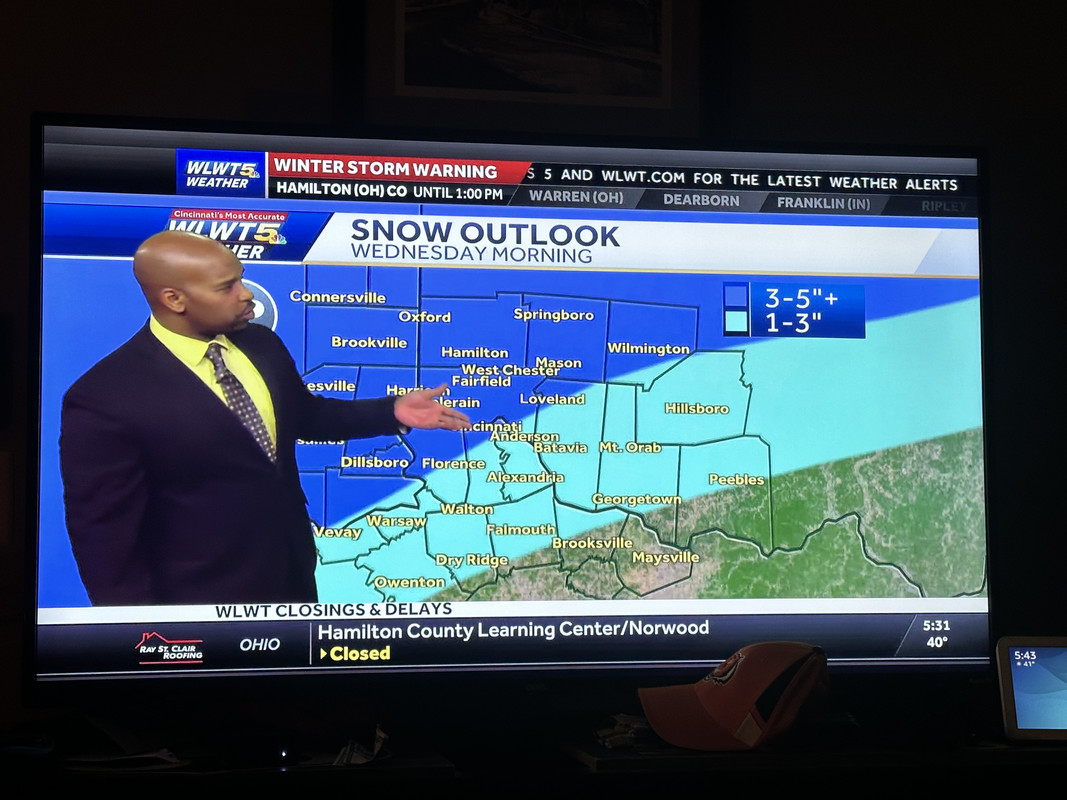
21Z RAP and HRRR also track the low thru our SE IN counties.
Ohio Valley Weather Observation & Discussion
https://absolutevorticity.com/
Gummers map is a good forecast. That is reasonable.
That map looks familiarBookNerdCarp wrote: ↑Tue Jan 24, 2023 5:45 pm Kevin Robinson
Basically the same. Said my hood would see ZIP lol
Agreed! I would like for the low to track near Cincy instead of West thru SE IN. But oh well. At least we can add a bit more to our seasonal total so I'm thankful for that.
EU did another great job with the low track in general from at least 6 days ago and didn't waiver much at all
Thanks for the reply. I was just wondering if a big storm like that can affect the pressure for a period of time. This was around Houston and it drop very quickly for a couple of hours and once the storm was pass them it started to rise. During that same time though other areas nearby just had the normal slight rise or slight decrease in pressures.tron777 wrote: ↑Tue Jan 24, 2023 4:47 pmI'll chime in on this too... Tim, are you referring to the SPC Meso Page on this?Trevor wrote: ↑Tue Jan 24, 2023 4:35 pmInteresting question! But that’s far too mesoscale to affect the modeling output. But I like your line of thinking there!tpweather wrote: ↑Tue Jan 24, 2023 3:47 pm Quick question for the folks well above my pay level? When I saw the big pressure drop near Houston a thunderstorm with a possible tornado was nearby. Does this cause a bigger pressure change for a brief period and then it returns to what the output was showing before. I have no clue on this because the pressures are starting to go down further northeast but seem to be falling back into that 1000- 1004 area.
Or maybe it sounds like you weren’t referring to it affecting modeling. Apologies if I misread.
Hey Brice! How's it going? Haven't seen you around in a long time. Hope all is well!briceg09 wrote: ↑Tue Jan 24, 2023 6:32 pm Make sure you guys are checking https://mping.ou.edu/display/ and https://www.spc.noaa.gov/exper/mesoanalysis/
If the models show different conditions than what is on the ground, then they will probably be wrong about what will happen here. We need to check downstream to make a nowcast for us.
This is why so many were wrong about the effects of the snow and driving conditions Sunday morning. People don't care about how many inches that definitely helps them decide what to do but they need to know how it will affect them.
I get what you're saying now Tim. Thanks for clarifying! I believe so yes. I think the pressure can drop suddenly right before a tornado. People have sometimes reported that their ears pop. You've probably had that happen when driving thru the mountains. I think it's kind of the same concept here. The change in pressure impacts our inner ears.tpweather wrote: ↑Tue Jan 24, 2023 7:09 pmThanks for the reply. I was just wondering if a big storm like that can affect the pressure for a period of time. This was around Houston and it drop very quickly for a couple of hours and once the storm was pass them it started to rise. During that same time though other areas nearby just had the normal slight rise or slight decrease in pressures.tron777 wrote: ↑Tue Jan 24, 2023 4:47 pmI'll chime in on this too... Tim, are you referring to the SPC Meso Page on this?Trevor wrote: ↑Tue Jan 24, 2023 4:35 pmInteresting question! But that’s far too mesoscale to affect the modeling output. But I like your line of thinking there!tpweather wrote: ↑Tue Jan 24, 2023 3:47 pm Quick question for the folks well above my pay level? When I saw the big pressure drop near Houston a thunderstorm with a possible tornado was nearby. Does this cause a bigger pressure change for a brief period and then it returns to what the output was showing before. I have no clue on this because the pressures are starting to go down further northeast but seem to be falling back into that 1000- 1004 area.
Or maybe it sounds like you weren’t referring to it affecting modeling. Apologies if I misread.
Thanks Les and they did report a tornado at that time. So I am not going crazy after alltron777 wrote: ↑Tue Jan 24, 2023 7:28 pmI get what you're saying now Tim. Thanks for clarifying! I believe so yes. I think the pressure can drop suddenly right before a tornado. People have sometimes reported that their ears pop. You've probably had that happen when driving thru the mountains. I think it's kind of the same concept here. The change in pressure impacts our inner ears.tpweather wrote: ↑Tue Jan 24, 2023 7:09 pmThanks for the reply. I was just wondering if a big storm like that can affect the pressure for a period of time. This was around Houston and it drop very quickly for a couple of hours and once the storm was pass them it started to rise. During that same time though other areas nearby just had the normal slight rise or slight decrease in pressures.tron777 wrote: ↑Tue Jan 24, 2023 4:47 pmI'll chime in on this too... Tim, are you referring to the SPC Meso Page on this?Trevor wrote: ↑Tue Jan 24, 2023 4:35 pmInteresting question! But that’s far too mesoscale to affect the modeling output. But I like your line of thinking there!tpweather wrote: ↑Tue Jan 24, 2023 3:47 pm Quick question for the folks well above my pay level? When I saw the big pressure drop near Houston a thunderstorm with a possible tornado was nearby. Does this cause a bigger pressure change for a brief period and then it returns to what the output was showing before. I have no clue on this because the pressures are starting to go down further northeast but seem to be falling back into that 1000- 1004 area.
Or maybe it sounds like you weren’t referring to it affecting modeling. Apologies if I misread.
Not at all! At least not yet anyway. A few more of these nail biters and we may all go crazy!tpweather wrote: ↑Tue Jan 24, 2023 7:36 pmThanks Les and they did report a tornado at that time. So I am not going crazy after alltron777 wrote: ↑Tue Jan 24, 2023 7:28 pmI get what you're saying now Tim. Thanks for clarifying! I believe so yes. I think the pressure can drop suddenly right before a tornado. People have sometimes reported that their ears pop. You've probably had that happen when driving thru the mountains. I think it's kind of the same concept here. The change in pressure impacts our inner ears.tpweather wrote: ↑Tue Jan 24, 2023 7:09 pmThanks for the reply. I was just wondering if a big storm like that can affect the pressure for a period of time. This was around Houston and it drop very quickly for a couple of hours and once the storm was pass them it started to rise. During that same time though other areas nearby just had the normal slight rise or slight decrease in pressures.

