
I’m no storm surveyor - but this sure looks like EF5 damage to me. Mayfield.
Severe Weather Threat [Dec 10-11 2021]
Re: Severe Weather Threat [Dec 10-11 2021]
You do not have the required permissions to view the files attached to this post.
Mike B.
Miamisburg, OH
The KING of the domes!

Miamisburg, OH
The KING of the domes!
-
MVWxObserver
- Hurricane
- Posts: 7084
- Joined: Fri Feb 26, 2021 7:48 pm
- Location: Greenville, OH
Re: Severe Weather Threat [Dec 10-11 2021]
Hi Mike,
It looks like EF5 to me, too, with just a concrete foundation slab left behind often in cases of that velocity.
Eric
Greenville, OH
Greenville, OH
-
Bgoney

- Hurricane
- Posts: 5054
- Joined: Fri Feb 26, 2021 7:09 pm
- Location: East clermont, 3mls north of Williamsburg
Re: Severe Weather Threat [Dec 10-11 2021]
Bowling Green Area: Confirmed Tornado with EF-3 damage and wind speeds of 150 mph. Still assessing damage.
Proud owner of Best Guess Forecast Center (BGFC)
Former owner of Gut Feeling Forecast (GFF) and Doppler Infinity
Former owner of Gut Feeling Forecast (GFF) and Doppler Infinity

Re: Severe Weather Threat [Dec 10-11 2021]
Perhaps this book I’ve had for many years will be irrelevant?
You do not have the required permissions to view the files attached to this post.
Silverton, OH
Co-Owner of Ohio Valley Weather Center LLC
https://www.facebook.com/ovwcllc
Co-Owner of Ohio Valley Weather Center LLC
https://www.facebook.com/ovwcllc
Re: Severe Weather Threat [Dec 10-11 2021]
Yeah I’m thinking this tornado will surpass 1925 as far as track length. Hopefully we get nowhere near the 695 fatalities that 1925 had.
Mike B.
Miamisburg, OH
The KING of the domes!
Miamisburg, OH
The KING of the domes!
-
MVWxObserver
- Hurricane
- Posts: 7084
- Joined: Fri Feb 26, 2021 7:48 pm
- Location: Greenville, OH
Re: Severe Weather Threat [Dec 10-11 2021]
I'll have to add a copy of that to my home library sometime, bro.
My maternal grandmother was 7 yrs-old and resided in southwest Indiana when that historic storm system occurred.
Eric
Greenville, OH
Greenville, OH
Re: Severe Weather Threat [Dec 10-11 2021]
Image from Jack Sillin on Twitter - very detailed analysis of the Quad State tornado track (technically made it into Ohio!!)
You do not have the required permissions to view the files attached to this post.
Mike B.
Miamisburg, OH
The KING of the domes!
Miamisburg, OH
The KING of the domes!
-
MVWxObserver
- Hurricane
- Posts: 7084
- Joined: Fri Feb 26, 2021 7:48 pm
- Location: Greenville, OH
Re: Severe Weather Threat [Dec 10-11 2021]
Eric
Greenville, OH
Greenville, OH
-
MVWxObserver
- Hurricane
- Posts: 7084
- Joined: Fri Feb 26, 2021 7:48 pm
- Location: Greenville, OH
Re: Severe Weather Threat [Dec 10-11 2021]
Looks like that path went just south of Boone Co. Chilling how it made a beeline just past that area of north-central KY where Les and Tim are i.e.
Eric
Greenville, OH
Greenville, OH
-
MVWxObserver
- Hurricane
- Posts: 7084
- Joined: Fri Feb 26, 2021 7:48 pm
- Location: Greenville, OH
Re: Severe Weather Threat [Dec 10-11 2021]
https://weather.com/news/news/2021-12-1 ... =hp-slot-1
^^ 12 dead in Bowling Green
https://weather.com/storms/severe/video ... =hp-slot-3
^^ Drone view of Mayfield destruction
https://weather.com/photos/news/2021-12 ... =hp-slot-4
https://weather.com/storms/severe/video ... =hp-slot-5
^^ Amazon warehouse in IL
^^ 12 dead in Bowling Green
https://weather.com/storms/severe/video ... =hp-slot-3
^^ Drone view of Mayfield destruction
https://weather.com/photos/news/2021-12 ... =hp-slot-4
https://weather.com/storms/severe/video ... =hp-slot-5
^^ Amazon warehouse in IL
Eric
Greenville, OH
Greenville, OH
Re: Severe Weather Threat [Dec 10-11 2021]
Big kudos to the NWS in Paducah - looks like residents in the Mayfield and surrounding areas actually had about a two hour heads up on the tornado.
You do not have the required permissions to view the files attached to this post.
Mike B.
Miamisburg, OH
The KING of the domes!
Miamisburg, OH
The KING of the domes!
-
MVWxObserver
- Hurricane
- Posts: 7084
- Joined: Fri Feb 26, 2021 7:48 pm
- Location: Greenville, OH
Re: Severe Weather Threat [Dec 10-11 2021]
A church that my folks and I worshiped at in Raleigh, NC is having their Christmas cantata tonight.
May get some angels drumming and cymbals accompaniment in the next 45 minutes or so.
May get some angels drumming and cymbals accompaniment in the next 45 minutes or so.
You do not have the required permissions to view the files attached to this post.
Eric
Greenville, OH
Greenville, OH
Re: Severe Weather Threat [Dec 10-11 2021]
Last post on this I promise! Lol. But check this out - amazing - Hawaii blizzard and floods - Pacific Jet - transports into USA for historic December tornado outbreak. Now that’s teleconnections at work!
#KonaLow Pacific jet catastrophic December #tornado outbreak
#KonaLow
 Pacific jet catastrophic December #tornado outbreak
 Mike B.
Miamisburg, OH
The KING of the domes!
Miamisburg, OH
The KING of the domes!
Re: Severe Weather Threat [Dec 10-11 2021]
Great Post and the STJ has no doubt got its act in gear. We talked about this in November as the STJ was not ready to get in gear along with the polar jet staying well to the north and we ended up with a lackluster November over much of the country. This changed in early Dec and both decided to start playing ball here in the lower 48. The STJ looks to remain active and yes the polar jet heading further south and east. This should continue to be a very active second half of Dec and will the polar air push far enough south and east to get us into some winter weather. My guess is yes but what form will that entail. During the month of November the southeast ridge was barely there at all but once we hit December its reared its ugly head.cloudy72 wrote: ↑Sat Dec 11, 2021 8:59 pm Last post on this I promise! Lol. But check this out - amazing - Hawaii blizzard and floods - Pacific Jet - transports into USA for historic December tornado outbreak. Now that’s teleconnections at work!
#KonaLow
-
MVWxObserver
- Hurricane
- Posts: 7084
- Joined: Fri Feb 26, 2021 7:48 pm
- Location: Greenville, OH
Re: Severe Weather Threat [Dec 10-11 2021]
The death toll has topped 80 in KY alone. 

Eric
Greenville, OH
Greenville, OH
-
MVWxObserver
- Hurricane
- Posts: 7084
- Joined: Fri Feb 26, 2021 7:48 pm
- Location: Greenville, OH
Re: Severe Weather Threat [Dec 10-11 2021]
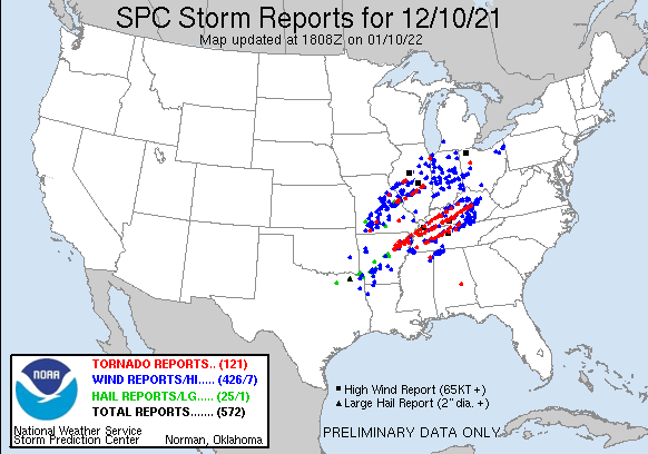
https://www.spc.noaa.gov/climo/reports/211210_rpts.gif
^^ Fri Dec 10th
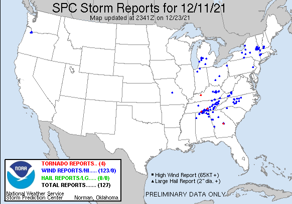
https://www.spc.noaa.gov/climo/reports/211211_rpts.gif
^^ Sat Dec 11th
561 reports from the 2 day event!
^^ Fri Dec 10th
https://www.spc.noaa.gov/climo/reports/211211_rpts.gif
^^ Sat Dec 11th
561 reports from the 2 day event!
Last edited by MVWxObserver on Mon Dec 13, 2021 6:25 pm, edited 3 times in total.
Eric
Greenville, OH
Greenville, OH
Re: Severe Weather Threat [Dec 10-11 2021]
Good Morning, I had a cousin who lived in Mayfield for many years before he retired. He was in the gun and rifle business for what company I am not sure of that. I know he lives in Alabama once he retired so he could hunt more often without the really cold weather for the most part. His daughter or my second cousin loved guns and ended up in law enforcement as a local cop,then detective on a railroad company,working for the FBI and then a secret service agent. That is someone who loves the law of the land.
-
MVWxObserver
- Hurricane
- Posts: 7084
- Joined: Fri Feb 26, 2021 7:48 pm
- Location: Greenville, OH
Re: Severe Weather Threat [Dec 10-11 2021]
Hi Tim,tpweather wrote: ↑Sun Dec 12, 2021 10:51 am Good Morning, I had a cousin who lived in Mayfield for many years before he retired. He was in the gun and rifle business for what company I am not sure of that. I know he lives in Alabama once he retired so he could hunt more often without the really cold weather for the most part. His daughter or my second cousin loved guns and ended up in law enforcement as a local cop,then detective on a railroad company,working for the FBI and then a secret service agent. That is someone who loves the law of the land.
I wonder if the building where your cousin had his business remained intact among the destruction?
We may never know.
Eric
Greenville, OH
Greenville, OH
-
MVWxObserver
- Hurricane
- Posts: 7084
- Joined: Fri Feb 26, 2021 7:48 pm
- Location: Greenville, OH
Re: Severe Weather Threat [Dec 10-11 2021]
https://www.whio.com/news/trending/kent ... SSYCCLBVU/
A family photo from Dawson Springs, KY ended up at a property in New Albany, IN in the storms.
The founder, thankfully, was able to connect with the owner via social media.
A family photo from Dawson Springs, KY ended up at a property in New Albany, IN in the storms.
The founder, thankfully, was able to connect with the owner via social media.
Eric
Greenville, OH
Greenville, OH
-
tron777

- Major Hurricane
- Posts: 25787
- Joined: Fri Feb 26, 2021 5:10 pm
- Location: Burlington, KY
- Contact:
Re: Severe Weather Threat [Dec 10-11 2021]
Leaving this up a while longer until we find out officially a few things this week. EF rating of the Mayfield, KY tornado and the actual track of that supercell that hammered folks from AR to KY.

Re: Severe Weather Threat [Dec 10-11 2021]
heard a report the Mayfield tornado had winds approaching 300 mph 800 ft above the ground. not sure what that translates to the surface but I imagine wind gusts of 200 mph maybe at ground level.
22'/23' snowfall > 11"
23'/24' snowfall > 19.5"
24'/25' snowfall > 24 "
23'/24' snowfall > 19.5"
24'/25' snowfall > 24 "
-
Bgoney
- Hurricane
- Posts: 5054
- Joined: Fri Feb 26, 2021 7:09 pm
- Location: East clermont, 3mls north of Williamsburg
Re: Severe Weather Threat [Dec 10-11 2021]
So far from LOU
Tornado damage found so far (as of 11pm Dec 12):
*Bowling Green Area: Confirmed tornado with EF-3 damage and wind speeds of 155 mph. Twelve fatalities. Still assessing damage.
*Ohio County: EF-3 tornado (140 mph winds). Still assessing damage.
*Hart County: EF-1 tornado (90 mph winds) in Horse Cave and EF-2 tornado (115 mph winds) in Hardyville
*Western Spencer County: EF-1 tornado (95 mph winds)
*Breckinridge/Grayson Counties: EF-1 tornado (105 mph winds) near Falls of Rough.
*Taylor County: EF-3 tornado (140 mph winds). One fatality. Still assessing damage.
Proud owner of Best Guess Forecast Center (BGFC)
Former owner of Gut Feeling Forecast (GFF) and Doppler Infinity
Former owner of Gut Feeling Forecast (GFF) and Doppler Infinity
-
Bgoney
- Hurricane
- Posts: 5054
- Joined: Fri Feb 26, 2021 7:09 pm
- Location: East clermont, 3mls north of Williamsburg
Re: Severe Weather Threat [Dec 10-11 2021]
IMO Mayfield will definitely be EF3 with EF4 damage mixed in
Proud owner of Best Guess Forecast Center (BGFC)
Former owner of Gut Feeling Forecast (GFF) and Doppler Infinity
Former owner of Gut Feeling Forecast (GFF) and Doppler Infinity
-
tron777
- Major Hurricane
- Posts: 25787
- Joined: Fri Feb 26, 2021 5:10 pm
- Location: Burlington, KY
- Contact:
Re: Severe Weather Threat [Dec 10-11 2021]
Found this from WAVE3 in LOU:
SURVEYS ONGOING (2:15PM MON): Here's what we know so far about the damage level from tornadoes in KY Dec 10-11. It will take a while longer to see any upgrades to EF-4 to EF-5 level damage as more time and national resources are needed. #WAVE3Weather app: https://qrco.de/bcAP8x
You do not have the required permissions to view the files attached to this post.
