March 2021 Weather Discussion
-
tron777

- Major Hurricane
- Posts: 25386
- Joined: Fri Feb 26, 2021 5:10 pm
- Location: Burlington, KY
- Contact:
Re: March 2021 Weather Discussion
We will be pretty windy until Friday night after midnight. Then... the winds will start to relax as high pressure builds in. Gusts in that 35 to 45 mph range should be common for a while. Probably 50+ to the north of the Tri-state.

-
young pup
- EF4 Tornado
- Posts: 753
- Joined: Wed Mar 03, 2021 7:13 pm
- Location: Grandview ( Westside of downtown CMH)
Re: March 2021 Weather Discussion
Now up to 1.10. Wind is picking up and the temp feels colder than it actually is.
-
MVWxObserver
- Hurricane
- Posts: 6889
- Joined: Fri Feb 26, 2021 7:48 pm
- Location: Greenville, OH
Re: March 2021 Weather Discussion
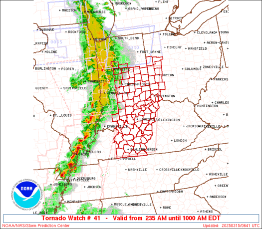
Hi Tim,tpweather wrote: ↑Thu Mar 18, 2021 3:09 pmHey Eric and just saw that and it looks like there is a tornado near Spartanburg and that is about 40 miles northeast of where the SC house is located . Looks like the Greenville area is a place that stronger storms form off the mountains but are not severe enough until it passes most of the area. This is what I have noticed over the past 2 years. Weather looks great down there early next week and have lots of outdoor things to keep me busy.MVWxObserver wrote: ↑Thu Mar 18, 2021 2:44 pm https://www.spc.noaa.gov/products/watch ... _radar.gif
Tim's Greenville, SC area under a Tornado Watch until 6 PM.
* Primary threats include...
A couple tornadoes possible
Isolated damaging wind gusts to 65 mph possible
Isolated large hail events to 1.5 inches in diameter possible
Sounds like your Greenville is in a great location re the topography and how the elements interact.
I found 1 report from SC ...
1940 UNK 2 NW CHAPPELLS NEWBERRY SC 3420 8189 CHAPPELLS FIRE DEPARTMENT REPORTED NUMEROUS TREES DOWN ALONG HWY 39 AND 56 NORTH OF CHAPPELLS. (CAE)
Eric
Greenville, OH
Greenville, OH
-
MVWxObserver
- Hurricane
- Posts: 6889
- Joined: Fri Feb 26, 2021 7:48 pm
- Location: Greenville, OH
Re: March 2021 Weather Discussion
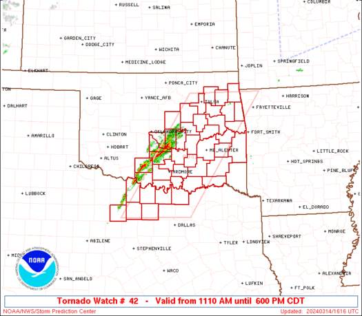
https://www.spc.noaa.gov/products/watch ... _radar.gif
My sister / her family and friends in Roanoke Rapids, NC and also friends in Raleigh under a Tornado Watch until 9 PM.
* Primary threats include...
A couple tornadoes possible
Isolated damaging wind gusts to 65 mph possible
Isolated large hail events to 1.5 inches in diameter possible
So far ...
2100 UNK 2 NNW ARCHDALE GUILFORD NC 3593 7998 TREES AND POWER LINES DOWN ON MODEL FARM RD. (RAH)
2100 UNK 2 NNW ARCHDALE GUILFORD NC 3593 7999 TREES AND POWER LINES DOWN ON THE SOUTH SIDE OF HIGH POINT ... INCLUDING AT SOUTH MAIN ST AND MODEL FARM RD. STRUCTURAL DAMAGE ALSO REPORTED IN THE AREA OF I-85 AND MAIN (RAH)
2125 UNK 5 NNE MARTHA RANDOLPH NC 3568 7997 TREES DOWN ALONG JACKSON CREEK RD. (RAH)
2140 UNK 2 S GIBSONVILLE GUILFORD NC 3607 7954 ROOFS OFF HOUSES ... MULTIPLE TREES DOWN ALONG ETHANS WAY. (RAH)
2143 100 1 NE SUGAR GROVE WATAUGA NC 3627 8177 (RNK)
2150 UNK 2 SSW PLYLER STANLY NC 3534 8030 CORRECTS PREVIOUS TSTM WND DMG REPORT FROM 2 SSW PLYLER. 1 TREE REPORTED DOWN. (RAH)
2150 UNK 1 S ELON COLLEGE ALAMANCE NC 3608 7951 OVERTURNED AND DAMAGED BUS FROM THUNDERSTORM WINDS REPORTED. (RAH)
2202 UNK 2 SSW PLYLER STANLY NC 3534 8030 1 TREE REPORTED DOWN. (RAH)
2207 UNK 2 SSE CARR ORANGE NC 3620 7920 TREES DOWN AND ROOFS OFF HOUSE ALONG PENTECOST RD. (RAH)
0030 UNK 3 E GASTON NORTHAMPTON NC 3649 7759 DAMAGE TO A BARN ON BLYTHE ROAD. TIME ESTIMATED BY RADAR. (AKQ)
Last edited by MVWxObserver on Thu Mar 18, 2021 11:38 pm, edited 4 times in total.
Eric
Greenville, OH
Greenville, OH

Re: March 2021 Weather Discussion
HRRR continues to advertise gust potential for Cincinnati (Hamilton Co) between 40-45mph with isolated higher gusts as is always the case with situations like this. They may add in another row or two of counties at some point this evening as we discussed earlier. Either way it’ll be windy.
Edit: it’s been a breezy afternoon, but winds will really begin to crank up over the next couple of hours. Sooner north of town.
Edit: it’s been a breezy afternoon, but winds will really begin to crank up over the next couple of hours. Sooner north of town.
Silverton, OH
Co-Owner of Ohio Valley Weather Center LLC
https://www.facebook.com/ovwcllc
Co-Owner of Ohio Valley Weather Center LLC
https://www.facebook.com/ovwcllc
-
MVWxObserver
- Hurricane
- Posts: 6889
- Joined: Fri Feb 26, 2021 7:48 pm
- Location: Greenville, OH
Re: March 2021 Weather Discussion
Probably will set my alarm to take the trash cart out to the curb since the Wind Advisory doesn't expire until 5 AM.
Currently 36 here in G'ville and going for around 27 Fri morning.
Currently 36 here in G'ville and going for around 27 Fri morning.
Eric
Greenville, OH
Greenville, OH
-
tron777
- Major Hurricane
- Posts: 25386
- Joined: Fri Feb 26, 2021 5:10 pm
- Location: Burlington, KY
- Contact:
Re: March 2021 Weather Discussion
18Z GFS wants to flood the OV and esp KY thru the end of March. Glad we have a lot of time to watch this unfold. Lot of storminess if correct regardless. 
Thanks to Aaron for adding a total of 21 pages of smiles for you guys to choose from. One of my personal favorites here!
Thanks to Aaron for adding a total of 21 pages of smiles for you guys to choose from. One of my personal favorites here!
-
MVWxObserver
- Hurricane
- Posts: 6889
- Joined: Fri Feb 26, 2021 7:48 pm
- Location: Greenville, OH
Re: March 2021 Weather Discussion
1755 UNK 6 ENE GRAYSON LAKE STATE PARK CARTER KY 3824 8291 SEVERAL LARGE LIMBS AND A SMALL TREE DOWN ALONG NEW CASTLE LN. ESTIMATED DIME SIZE HAIL OBSERVED AS WELL. TIME ESTIMATED FROM RADAR. (RLX)
2019 100 HATFIELD STATION PIKE KY 3773 8238 HAIL RANGING IN SIZE FROM DIMES TO QUARTERS WAS OBSERVED IN HATFIELD. (JKL)
2104 150 9 WSW GALLIPOLIS GALLIA OH 3877 8235 MEASURED ... PICTURE PROVIDED. REPORTED UP TO ONE HALF INCH HAIL 10 MINUTES EARLIER. HAIL STOPPED AND STARTED AGAIN. (RLX)
2138 125 1 SW GALLIPOLIS GALLIA OH 3881 8221 REPORT FROM MPING: HALF DOLLAR (1.25 IN.). (RLX)
2140 125 GALLIPOLIS GALLIA OH 3882 8219 PICTURE FROM SOCIAL MEDIA OF 1.25 INCH HAIL. (RLX)
Last edited by MVWxObserver on Thu Mar 18, 2021 7:18 pm, edited 1 time in total.
Eric
Greenville, OH
Greenville, OH
-
tron777
- Major Hurricane
- Posts: 25386
- Joined: Fri Feb 26, 2021 5:10 pm
- Location: Burlington, KY
- Contact:
Re: March 2021 Weather Discussion
Temps continue to drop... 43 now imby. Should be in that 30 to 35 range overnight. Light rain is also pushing back in from the NW thanks to the backside of the low pressure system to our SE. Just one of those crappy nights unfortunately. A cold and windy Friday, but dry in the 40s.
-
MVWxObserver
- Hurricane
- Posts: 6889
- Joined: Fri Feb 26, 2021 7:48 pm
- Location: Greenville, OH
Re: March 2021 Weather Discussion
Event total for me is 2.40"! :grin:
Still currently 36 here in G'ville.
Still currently 36 here in G'ville.
Eric
Greenville, OH
Greenville, OH
-
tron777
- Major Hurricane
- Posts: 25386
- Joined: Fri Feb 26, 2021 5:10 pm
- Location: Burlington, KY
- Contact:
Re: March 2021 Weather Discussion
That wind is still roaring out there and will continue to do so today... finally diminishing tonight. Low 30s out there this morning. Highs in the mid to U40s for today. Chilly morning and nice afternoons though this weekend! Nice weather maybe touching 70 early next week. Then things get active again by mid week. So we get a little break before we have to forecast again. :grin: The rest of March continues to look active folks.
-
tron777
- Major Hurricane
- Posts: 25386
- Joined: Fri Feb 26, 2021 5:10 pm
- Location: Burlington, KY
- Contact:
Re: March 2021 Weather Discussion
Down to 32 now at CVG... overnight, we had a peak wind gust of 39 mph.

Re: March 2021 Weather Discussion
The highest gusts I saw in my hood overnight were about 40 mph.
Mike B.
Miamisburg, OH
The KING of the domes!

Miamisburg, OH
The KING of the domes!
-
tron777
- Major Hurricane
- Posts: 25386
- Joined: Fri Feb 26, 2021 5:10 pm
- Location: Burlington, KY
- Contact:
Re: March 2021 Weather Discussion
12Z GFS brings rain in by mid to late morning on Tues of next week. A break Wed then more rain by Thurs afternoon with the second low riding up the front. Then we get another system to move thru by that next weekend. The pattern looks busy after we enjoy a pleasant weekend into Monday of next week or so.
-
tron777
- Major Hurricane
- Posts: 25386
- Joined: Fri Feb 26, 2021 5:10 pm
- Location: Burlington, KY
- Contact:
Re: March 2021 Weather Discussion
12Z Euro continues the slower idea versus the GFS. The front tries to push in by Wed of next week but fails thanks to the SE ridge. Only a slight risk for rain at this time. Then the next low comes up the front for a wet Thurs. I still prefer the slower Euro idea at this time.
Re: March 2021 Weather Discussion
Hey Les and I am not sold on either solution and give a thumbs down to the Euro this past weekend in regards to rainfall totals locally though the others not much better. That has been an issue in the last 6 months and not sure why but my guess it had a lot to do with a La Nina though it played out more like an El Nino in some respects. Still expecting it to get very stormy over the next 6 weeks at least.tron777 wrote: ↑Fri Mar 19, 2021 2:31 pm 12Z Euro continues the slower idea versus the GFS. The front tries to push in by Wed of next week but fails thanks to the SE ridge. Only a slight risk for rain at this time. Then the next low comes up the front for a wet Thurs. I still prefer the slower Euro idea at this time.
-
tron777
- Major Hurricane
- Posts: 25386
- Joined: Fri Feb 26, 2021 5:10 pm
- Location: Burlington, KY
- Contact:
Re: March 2021 Weather Discussion
Hey Tim! I won't even begin to forecast rainfall totals yet for next week. I just like the slower timing due to a more robust looking SE ridge. The GFS is usually too fast anyway. That could change naturally. The Euro has bombed badly in the QPF dept without a doubt. No model really did well down our way with the last event QPF wise. Those 1-2" totals were about a hundred miles off LOL We are still on the same page in terms of an active pattern for the next several weeks which is typical for the Spring around here.tpweather wrote: ↑Fri Mar 19, 2021 4:33 pmHey Les and I am not sold on either solution and give a thumbs down to the Euro this past weekend in regards to rainfall totals locally though the others not much better. That has been an issue in the last 6 months and not sure why but my guess it had a lot to do with a La Nina though it played out more like an El Nino in some respects. Still expecting it to get very stormy over the next 6 weeks at least.tron777 wrote: ↑Fri Mar 19, 2021 2:31 pm 12Z Euro continues the slower idea versus the GFS. The front tries to push in by Wed of next week but fails thanks to the SE ridge. Only a slight risk for rain at this time. Then the next low comes up the front for a wet Thurs. I still prefer the slower Euro idea at this time.
-
Bgoney

- Tropical Storm
- Posts: 4973
- Joined: Fri Feb 26, 2021 7:09 pm
- Location: East clermont, 3mls north of Williamsburg
Re: March 2021 Weather Discussion
Hopefully we can say bye-bye to freezing Temps (CVG) after this weekend until the fall.
Proud owner of Best Guess Forecast Center (BGFC)
Former owner of Gut Feeling Forecast (GFF) and Doppler Infinity
Former owner of Gut Feeling Forecast (GFF) and Doppler Infinity
-
tron777
- Major Hurricane
- Posts: 25386
- Joined: Fri Feb 26, 2021 5:10 pm
- Location: Burlington, KY
- Contact:
Re: March 2021 Weather Discussion
That would be nice!
-
tron777
- Major Hurricane
- Posts: 25386
- Joined: Fri Feb 26, 2021 5:10 pm
- Location: Burlington, KY
- Contact:
Re: March 2021 Weather Discussion
31 this morning at CVG. 30 here for the low. Happy First Day of Spring folks! A gorgeous weekend on tap, other then the cool mornings. Enjoy it my friends. 

GFS has rain arriving around midday Tuesday. Euro still waiting until Wed. Both models agree on Thurs being the wettest day next week.
GFS has rain arriving around midday Tuesday. Euro still waiting until Wed. Both models agree on Thurs being the wettest day next week.
-
Bgoney
- Tropical Storm
- Posts: 4973
- Joined: Fri Feb 26, 2021 7:09 pm
- Location: East clermont, 3mls north of Williamsburg
Re: March 2021 Weather Discussion
27 here for low
Proud owner of Best Guess Forecast Center (BGFC)
Former owner of Gut Feeling Forecast (GFF) and Doppler Infinity
Former owner of Gut Feeling Forecast (GFF) and Doppler Infinity
-
tron777
- Major Hurricane
- Posts: 25386
- Joined: Fri Feb 26, 2021 5:10 pm
- Location: Burlington, KY
- Contact:
Re: March 2021 Weather Discussion
No changes really over the next week from the 12Z GFS. See my morning post and you're caught up lol Mid 50s across the area now. Can someone hit 60 this afternoon?
-
tron777
- Major Hurricane
- Posts: 25386
- Joined: Fri Feb 26, 2021 5:10 pm
- Location: Burlington, KY
- Contact:
Re: March 2021 Weather Discussion
No change from the 12Z Euro either. A few light showers Wed with Thursday being the wettest day.
Re: March 2021 Weather Discussion
I believe we have one more round of 32 or below. What has happen over the past few weeks is a very strong PV for March. This of course has kept the cold in the arctic regions and they have been below normal in terms of temps. With tons of storminess over the next few weeks I believe one of those systems will be strong enough where we tap some of that really cold air and may be just enough to give us that last round of freezing temps. The southern 2/3rds of Canada has been average or above in terms of temps so this does happen this time of year with a stronger than normal PV.
