White Christmas Blizzard 2022
-
tron777

- Major Hurricane
- Posts: 25386
- Joined: Fri Feb 26, 2021 5:10 pm
- Location: Burlington, KY
- Contact:
Re: I'm Dreaming of a White Christmas 2022
Wow... still seeing obs out in the Plains of -10 degrees with mod to hvy snow. Still seeing some snow squall warnings as well. This system has a kick! Remember the satellite pic I posted? I swear it (and this isn't beer talking either, I just ate dinner and cracked open my first one LOL)... but anyway, I swear to you all, something very special could happen with this system. Whether it is a positive gain for snow lovers remains to be seen. I just have a "giddy" feeling about this one.

-
tron777
- Major Hurricane
- Posts: 25386
- Joined: Fri Feb 26, 2021 5:10 pm
- Location: Burlington, KY
- Contact:
Re: I'm Dreaming of a White Christmas 2022
Some of the more SE model solutions were digging this thing down into New Mexico and West Texas. As you said, I don't know either but it's worth watching IMO all the same.tpweather wrote: ↑Wed Dec 21, 2022 6:48 pm Starting to look at pressure falls and we know in the northern plains with that piece of energy moving east that the pressures are falling but also notice the fall in western Texas. Will the pressure fall in Texas become a area of low pressure that could ride up the front and I don't know the answer.
-
BookNerdCarp

- EF1 Tornado
- Posts: 416
- Joined: Fri Feb 26, 2021 5:57 pm
Re: I'm Dreaming of a White Christmas 2022
I think CB is going to need a GoFund Me LOL - Down again
*_*_*_*_*_*_*_*_*_*_*_*_*_*_*_*_*_*_*_*_*_*
Ripley, OH (Brown County)
Home of the "Cold Rain Haters"
*_*_*_*_*_*_*_*_*_*_*_*_*_*_*_*_*_*_*_*_*_*
Ripley, OH (Brown County)
Home of the "Cold Rain Haters"
*_*_*_*_*_*_*_*_*_*_*_*_*_*_*_*_*_*_*_*_*_*
-
tron777
- Major Hurricane
- Posts: 25386
- Joined: Fri Feb 26, 2021 5:10 pm
- Location: Burlington, KY
- Contact:
Re: I'm Dreaming of a White Christmas 2022
18Z Euro coming in... checking...
Re: I'm Dreaming of a White Christmas 2022
I agree Les and I don't believe we have underplayed or overplayed the factors that make this system a little special. Recent trends have to boost snow totals up some and that is with a quicker arrival but also more precip than say 24 hours ago. Will that continue and we just need to watch to the west of here and see if the storm is overproducing. Funny because late last night and early today the snow totals sort of went down in some areas of the central plains only to rise again this afternoon. That is a pretty wild shift in 24 hours. To me and I have said this since we saw the storm coming which has been on our radar for awhile that this type of cold is almost impossible for models to figure out and the reason is very seldom do you get these true cross-polar air masses that are so broad like this one and I believe they are still underestimating the cold.tron777 wrote: ↑Wed Dec 21, 2022 6:51 pm Wow... still seeing obs out in the Plains of -10 degrees with mod to hvy snow. Still seeing some snow squall warnings as well. This system has a kick! Remember the satellite pic I posted? I swear it (and this isn't beer talking either, I just ate dinner and cracked open my first one LOL)... but anyway, I swear to you all, something very special could happen with this system. Whether it is a positive gain for snow lovers remains to be seen. I just have a "giddy" feeling about this one.
-
tron777
- Major Hurricane
- Posts: 25386
- Joined: Fri Feb 26, 2021 5:10 pm
- Location: Burlington, KY
- Contact:
Re: I'm Dreaming of a White Christmas 2022
I think what the 12Z Euro tried to do was phase in, or inject some of the moisture off of the Atlantic from that East Coast system, Waiting to see if 18Z Euro does the same. But that's one reason why the 12Z run was so much higher.
-
tron777
- Major Hurricane
- Posts: 25386
- Joined: Fri Feb 26, 2021 5:10 pm
- Location: Burlington, KY
- Contact:
Re: I'm Dreaming of a White Christmas 2022
No doubt Tim! The cold is coming faster then model projections, which you have said numerous times, and it is colder air then models are projecting (although getting a little better now). I think that piggy-backs to what Aaron and I were talking about earlier. Models simply don't have the logic programmed in them to handle extreme set up's. We're better then we used to be. We picked up on this storm ages ago to your point. But the devil is in the details and our technology just isn't there yet. Hell, we picked up on this wonderful blocking pattern 3-4 weeks ago. Heck of a long range call by everyone here at AV. We deserve a pat on the back for that at least.tpweather wrote: ↑Wed Dec 21, 2022 6:59 pmI agree Les and I don't believe we have underplayed or overplayed the factors that make this system a little special. Recent trends have to boost snow totals up some and that is with a quicker arrival but also more precip than say 24 hours ago. Will that continue and we just need to watch to the west of here and see if the storm is overproducing. Funny because late last night and early today the snow totals sort of went down in some areas of the central plains only to rise again this afternoon. That is a pretty wild shift in 24 hours. To me and I have said this since we saw the storm coming which has been on our radar for awhile that this type of cold is almost impossible for models to figure out and the reason is very seldom do you get these true cross-polar air masses that are so broad like this one and I believe they are still underestimating the cold.tron777 wrote: ↑Wed Dec 21, 2022 6:51 pm Wow... still seeing obs out in the Plains of -10 degrees with mod to hvy snow. Still seeing some snow squall warnings as well. This system has a kick! Remember the satellite pic I posted? I swear it (and this isn't beer talking either, I just ate dinner and cracked open my first one LOL)... but anyway, I swear to you all, something very special could happen with this system. Whether it is a positive gain for snow lovers remains to be seen. I just have a "giddy" feeling about this one.
Re: I'm Dreaming of a White Christmas 2022
I thought about that but I have a hard time believing that would happen. Having such a strong cold front pushing in plus we know just getting Atlantic moisture over the mountains and getting it this far west is never easy unless you have the perfect path and I believe a stronger east coast storm. Who knows and you may be correct. Les yes we did well with this pattern plus we also picked up on the cold spell in mid-November before anyone that I know of so this fall season into winter we have done well with seeing pattern changes and hopefully we can continue that process but also do well on individual storms like the current one.
-
tron777
- Major Hurricane
- Posts: 25386
- Joined: Fri Feb 26, 2021 5:10 pm
- Location: Burlington, KY
- Contact:
Re: I'm Dreaming of a White Christmas 2022
Oh yeah baby! 18Z Euro...
CVG....
THU 12Z 22-DEC 1.5 0.9 1017 95 93 0.04 555 541
THU 15Z 22-DEC 2.8 0.9 1016 98 92 0.04 555 542
THU 18Z 22-DEC 4.5 0.9 1011 96 59 0.05 552 543
THU 21Z 22-DEC 5.5 0.5 1008 97 36 0.00 547 541
FRI 00Z 23-DEC 5.1 -0.4 1004 99 100 0.04 542 538
FRI 03Z 23-DEC -2.6 -2.9 1004 91 98 0.17 535 532
FRI 06Z 23-DEC -12.5 -12.8 1008 70 100 0.32 526 519
FRI 09Z 23-DEC -17.5 -22.6 1013 63 90 0.05 516 506
FRI 12Z 23-DEC -21.0 -26.9 1018 59 34 0.06 512 499
Re: I'm Dreaming of a White Christmas 2022
The trend continue Les!!!!tron777 wrote: ↑Wed Dec 21, 2022 7:09 pm Oh yeah baby! 18Z Euro...
CVG....
THU 12Z 22-DEC 1.5 0.9 1017 95 93 0.04 555 541
THU 15Z 22-DEC 2.8 0.9 1016 98 92 0.04 555 542
THU 18Z 22-DEC 4.5 0.9 1011 96 59 0.05 552 543
THU 21Z 22-DEC 5.5 0.5 1008 97 36 0.00 547 541
FRI 00Z 23-DEC 5.1 -0.4 1004 99 100 0.04 542 538
FRI 03Z 23-DEC -2.6 -2.9 1004 91 98 0.17 535 532
FRI 06Z 23-DEC -12.5 -12.8 1008 70 100 0.32 526 519
FRI 09Z 23-DEC -17.5 -22.6 1013 63 90 0.05 516 506
FRI 12Z 23-DEC -21.0 -26.9 1018 59 34 0.06 512 499
-
tron777
- Major Hurricane
- Posts: 25386
- Joined: Fri Feb 26, 2021 5:10 pm
- Location: Burlington, KY
- Contact:
Re: I'm Dreaming of a White Christmas 2022
You do not have the required permissions to view the files attached to this post.
-
tron777
- Major Hurricane
- Posts: 25386
- Joined: Fri Feb 26, 2021 5:10 pm
- Location: Burlington, KY
- Contact:
Re: I'm Dreaming of a White Christmas 2022
Anybody got a Kuchera map so I can go all out snow weenie on it? Thanks! 
Re: I'm Dreaming of a White Christmas 2022
I saw Brian's video earlier and he talked about how the jet is further south and there may be some action that could lead to a low pressure to our south or at least something that would bring more lift into the storm. I was a little surprised he had us already in the 4-6 inch range because he does not overreact to model runs.
-
tron777
- Major Hurricane
- Posts: 25386
- Joined: Fri Feb 26, 2021 5:10 pm
- Location: Burlington, KY
- Contact:
Re: I'm Dreaming of a White Christmas 2022
SPC now showing a 1050 contour pushing into MT. We know that will continue to grow into the 1060s for the max pressure tomorrow. 1008 MB low over the CO / OK / TX Panhandle area continuing to get better organized and not as stretched out. Pressure falls continue to the SE all the way down to San Antonio, in South Central TX. As I said, dig baby dig. Keep on digging as low as you can go. The better off snow lovers around here will be.
-
tron777
- Major Hurricane
- Posts: 25386
- Joined: Fri Feb 26, 2021 5:10 pm
- Location: Burlington, KY
- Contact:
Re: I'm Dreaming of a White Christmas 2022
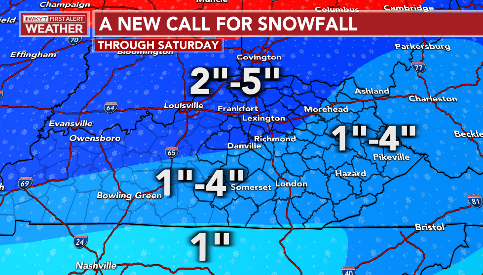
CB's got a new call for snowfall if you can get it to load.
https://kyweathercenter.com/?p=57013
Lucky for you, I did! Here's his new map:
The blog post mentions that he may not be done yet with the totals and to expect warnings to be upgraded at some point.
https://kyweathercenter.com/?p=57013
Lucky for you, I did!
The blog post mentions that he may not be done yet with the totals and to expect warnings to be upgraded at some point.
You do not have the required permissions to view the files attached to this post.
-
BookNerdCarp
- EF1 Tornado
- Posts: 416
- Joined: Fri Feb 26, 2021 5:57 pm
Re: I'm Dreaming of a White Christmas 2022
Beat me to it Les lol
CB’s new map
CB’s new map
Last edited by BookNerdCarp on Wed Dec 21, 2022 7:21 pm, edited 1 time in total.
*_*_*_*_*_*_*_*_*_*_*_*_*_*_*_*_*_*_*_*_*_*
Ripley, OH (Brown County)
Home of the "Cold Rain Haters"
*_*_*_*_*_*_*_*_*_*_*_*_*_*_*_*_*_*_*_*_*_*
Ripley, OH (Brown County)
Home of the "Cold Rain Haters"
*_*_*_*_*_*_*_*_*_*_*_*_*_*_*_*_*_*_*_*_*_*
-
tron777
- Major Hurricane
- Posts: 25386
- Joined: Fri Feb 26, 2021 5:10 pm
- Location: Burlington, KY
- Contact:
Re: I'm Dreaming of a White Christmas 2022
I was absolutely shocked by WAVE's map. But as Chuck said, WHAS in Louisville had the same forecast. Is anyone aware of our Local Cincy Mets going that high? Local 12 had 2-4". I don't watch the other channels.tpweather wrote: ↑Wed Dec 21, 2022 7:13 pm I saw Brian's video earlier and he talked about how the jet is further south and there may be some action that could lead to a low pressure to our south or at least something that would bring more lift into the storm. I was a little surprised he had us already in the 4-6 inch range because he does not overreact to model runs.
Re: I'm Dreaming of a White Christmas 2022
Les I would love to see this trough dig. I have been trying since the weekend to get a low to form on the southeast coast of Texas and the darn models would not agree with me at all lol. Btw got a nice rum punch that I am drinking and one nice 12 ounce glass will be plenty because I can only drink so much in the way of sweet drinks and usually I am just a beer drinker.tron777 wrote: ↑Wed Dec 21, 2022 7:18 pm SPC now showing a 1050 contour pushing into MT. We know that will continue to grow into the 1060s for the max pressure tomorrow. 1008 MB low over the CO / OK / TX Panhandle area continuing to get better organized and not as stretched out. Pressure falls continue to the SE all the way down to San Antonio, in South Central TX. As I said, dig baby dig. Keep on digging as low as you can go. The better off snow lovers around here will be.
Re: I'm Dreaming of a White Christmas 2022
Did CB steal my forecast lol
Re: I'm Dreaming of a White Christmas 2022
Saw Kevin at 5pm and he mentioned several times that the trend for higher snow totals was happening each and every run and was looking at that part of the forecast. Matter of fact he was leaning towards the 3-6 inch amounts and yesterday he was on the 1-3 rangetron777 wrote: ↑Wed Dec 21, 2022 7:21 pmI was absolutely shocked by WAVE's map. But as Chuck said, WHAS in Louisville had the same forecast. Is anyone aware of our Local Cincy Mets going that high? Local 12 had 2-4". I don't watch the other channels.tpweather wrote: ↑Wed Dec 21, 2022 7:13 pm I saw Brian's video earlier and he talked about how the jet is further south and there may be some action that could lead to a low pressure to our south or at least something that would bring more lift into the storm. I was a little surprised he had us already in the 4-6 inch range because he does not overreact to model runs.
Last edited by tpweather on Wed Dec 21, 2022 7:27 pm, edited 1 time in total.
Re: I'm Dreaming of a White Christmas 2022
Holy Euro!
15:1?
15:1?
Re: I'm Dreaming of a White Christmas 2022
Steve H on 19 was putting "Euro Model Data" on the screen and calling for an inch or less in downtown. Not sure what he is considering "Euro Model Data" because it's been higher than that for 24 hours now if I'm not mistaken!tpweather wrote: ↑Wed Dec 21, 2022 7:25 pmSaw Kevin at 5pm and he mentioned several times that the trend for higher snow totals was happening each and every run and was looking at that part of the forecast.tron777 wrote: ↑Wed Dec 21, 2022 7:21 pmI was absolutely shocked by WAVE's map. But as Chuck said, WHAS in Louisville had the same forecast. Is anyone aware of our Local Cincy Mets going that high? Local 12 had 2-4". I don't watch the other channels.tpweather wrote: ↑Wed Dec 21, 2022 7:13 pm I saw Brian's video earlier and he talked about how the jet is further south and there may be some action that could lead to a low pressure to our south or at least something that would bring more lift into the storm. I was a little surprised he had us already in the 4-6 inch range because he does not overreact to model runs.
-
tron777
- Major Hurricane
- Posts: 25386
- Joined: Fri Feb 26, 2021 5:10 pm
- Location: Burlington, KY
- Contact:
Re: I'm Dreaming of a White Christmas 2022
Another model bust... Models are dead wrong with the timing of the arctic front and busting badly on temps. This means that the cold is coming sooner and harder!
I could post tons of these! The internet is full of them right now.
I could post tons of these! The internet is full of them right now.
Re: I'm Dreaming of a White Christmas 2022
He has his own model and tell you the truth I have no ideal what kind of models he blends together.Mfitz730 wrote: ↑Wed Dec 21, 2022 7:28 pmSteve H on 19 was putting "Euro Model Data" on the screen and calling for an inch or less in downtown. Not sure what he is considering "Euro Model Data" because it's been higher than that for 24 hours now if I'm not mistaken!tpweather wrote: ↑Wed Dec 21, 2022 7:25 pmSaw Kevin at 5pm and he mentioned several times that the trend for higher snow totals was happening each and every run and was looking at that part of the forecast.tron777 wrote: ↑Wed Dec 21, 2022 7:21 pmI was absolutely shocked by WAVE's map. But as Chuck said, WHAS in Louisville had the same forecast. Is anyone aware of our Local Cincy Mets going that high? Local 12 had 2-4". I don't watch the other channels.tpweather wrote: ↑Wed Dec 21, 2022 7:13 pm I saw Brian's video earlier and he talked about how the jet is further south and there may be some action that could lead to a low pressure to our south or at least something that would bring more lift into the storm. I was a little surprised he had us already in the 4-6 inch range because he does not overreact to model runs.
-
BookNerdCarp
- EF1 Tornado
- Posts: 416
- Joined: Fri Feb 26, 2021 5:57 pm
Re: I'm Dreaming of a White Christmas 2022
Mfitz730 wrote: ↑Wed Dec 21, 2022 7:28 pmSteve H on 19 was putting "Euro Model Data" on the screen and calling for an inch or less in downtown. Not sure what he is considering "Euro Model Data" because it's been higher than that for 24 hours now if I'm not mistaken!tpweather wrote: ↑Wed Dec 21, 2022 7:25 pmSaw Kevin at 5pm and he mentioned several times that the trend for higher snow totals was happening each and every run and was looking at that part of the forecast.tron777 wrote: ↑Wed Dec 21, 2022 7:21 pmI’m sorry but I just feel like he is the worst forecaster. My humble opinion.tpweather wrote: ↑Wed Dec 21, 2022 7:13 pm I saw Brian's video earlier and he talked about how the jet is further south and there may be some action that could lead to a low pressure to our south or at least something that would bring more lift into the storm. I was a little surprised he had us already in the 4-6 inch range because he does not overreact to model runs.
I was absolutely shocked by WAVE's map. But as Chuck said, WHAS in Louisville had the same forecast. Is anyone aware of our Local Cincy Mets going that high? Local 12 had 2-4". I don't watch the other channels.
*_*_*_*_*_*_*_*_*_*_*_*_*_*_*_*_*_*_*_*_*_*
Ripley, OH (Brown County)
Home of the "Cold Rain Haters"
*_*_*_*_*_*_*_*_*_*_*_*_*_*_*_*_*_*_*_*_*_*
Ripley, OH (Brown County)
Home of the "Cold Rain Haters"
*_*_*_*_*_*_*_*_*_*_*_*_*_*_*_*_*_*_*_*_*_*
