January 2022 Weather Discussion
-
tron777

- Major Hurricane
- Posts: 25378
- Joined: Fri Feb 26, 2021 5:10 pm
- Location: Burlington, KY
- Contact:
Re: January 2022 Weather Discussion
No changes from me... flake chance on Sunday, something more meaningful around the 6-7th timeframe then another shot to watch out for around the 9-10th give or take.

-
tron777
- Major Hurricane
- Posts: 25378
- Joined: Fri Feb 26, 2021 5:10 pm
- Location: Burlington, KY
- Contact:
Re: January 2022 Weather Discussion
Current MJO plot as of 12/28 per the Aussies:
You do not have the required permissions to view the files attached to this post.

Re: January 2022 Weather Discussion
It's like hitting a concrete wall LOL
Mike B.
Miamisburg, OH
The KING of the domes!

Miamisburg, OH
The KING of the domes!
-
tron777
- Major Hurricane
- Posts: 25378
- Joined: Fri Feb 26, 2021 5:10 pm
- Location: Burlington, KY
- Contact:
Re: January 2022 Weather Discussion
Just hope it gets closer to 8 before dying.
-
tron777
- Major Hurricane
- Posts: 25378
- Joined: Fri Feb 26, 2021 5:10 pm
- Location: Burlington, KY
- Contact:
Re: January 2022 Weather Discussion
Nice thump on 1/6 per the 12Z GFS. Matches up with prior Euro runs.

Re: January 2022 Weather Discussion
Some model porn for ya next Thu/Fri, Les!
Silverton, OH
Co-Owner of Ohio Valley Weather Center LLC
https://www.facebook.com/ovwcllc
Co-Owner of Ohio Valley Weather Center LLC
https://www.facebook.com/ovwcllc
-
tron777
- Major Hurricane
- Posts: 25378
- Joined: Fri Feb 26, 2021 5:10 pm
- Location: Burlington, KY
- Contact:
Re: January 2022 Weather Discussion
Hoping it is our first legit threat. Need it within 4 or 5 days to make a thread on it lol
-
tron777
- Major Hurricane
- Posts: 25378
- Joined: Fri Feb 26, 2021 5:10 pm
- Location: Burlington, KY
- Contact:
Re: January 2022 Weather Discussion
12Z CMC has the system but it's faster and stronger / to far north with the low track. We've got enough model support for their to be a system. Just a matter of rain or snow or both? 
-
tron777
- Major Hurricane
- Posts: 25378
- Joined: Fri Feb 26, 2021 5:10 pm
- Location: Burlington, KY
- Contact:
Re: January 2022 Weather Discussion
12Z GEFS Members show everything from rain, rain to snow and all snow. Typical this far away but on or around 1/6 looking like a storm threat of some kind if brewing.
-
tron777
- Major Hurricane
- Posts: 25378
- Joined: Fri Feb 26, 2021 5:10 pm
- Location: Burlington, KY
- Contact:
Re: January 2022 Weather Discussion
12Z GEFS after 1/10 have a nice +PNA / -EPO combo but a +AO / +NAO as we lose the blocking up top and on the Atlantic side. To me, it is far better to have a good Pacific, which I think we'll have. So chances for snow will be there.
-
tron777
- Major Hurricane
- Posts: 25378
- Joined: Fri Feb 26, 2021 5:10 pm
- Location: Burlington, KY
- Contact:
Re: January 2022 Weather Discussion
Fantasy Land obviously but 12Z GFS text data for the 1/6 event at CVG - 2" per hour anyone?
Code: Select all
FRI 00Z 07-JAN  -0.6    -2.5    1011      98      97    0.44     547     539
FRI 06Z 07-JAN  -4.2    -8.0    1015      95      96    0.52     537     526
FRI 12Z 07-JAN -10.8    -9.6    1022      93      22    0.01     539     522
-
tron777
- Major Hurricane
- Posts: 25378
- Joined: Fri Feb 26, 2021 5:10 pm
- Location: Burlington, KY
- Contact:
Re: January 2022 Weather Discussion
12Z Canadian Ensemble also agrees with the GEFS Days 10 to 15. Cold pattern here with snow chances / mix etc. It's good to see the brutal cold not move in so we're not going to be cold and dry. We're on the edges of each southward advancing arctic airmass as the snowpack builds to our north and NW.
-
tron777
- Major Hurricane
- Posts: 25378
- Joined: Fri Feb 26, 2021 5:10 pm
- Location: Burlington, KY
- Contact:
Re: January 2022 Weather Discussion
For 1/6: 12Z Euro coming in warmer / north with a cold 33/34 and rain at CVG. Snow / mix to the north.
Re: January 2022 Weather Discussion
So how long until we see the Facebook posts and YouTube videos on the upcoming paralyzing devastating crippling won't survive blizzard on 1/6?
Mike B.
Miamisburg, OH
The KING of the domes!
Miamisburg, OH
The KING of the domes!
-
tron777
- Major Hurricane
- Posts: 25378
- Joined: Fri Feb 26, 2021 5:10 pm
- Location: Burlington, KY
- Contact:
Re: January 2022 Weather Discussion
In 3... 2... 1...
In all seriousness, the ejection of the wave from the Rockies is critical with a 1040 MB high sliding to the north to keep the cold air in. Need to see how much the shortwave digs and when. Chances for a moderate event to maybe heavy are there for just about anyone in the forum coverage area at this point.
Re: January 2022 Weather Discussion
The dogs want to put something out on my forum Les, but I have them leashed in for now. LOL
-
tron777
- Major Hurricane
- Posts: 25378
- Joined: Fri Feb 26, 2021 5:10 pm
- Location: Burlington, KY
- Contact:
Re: January 2022 Weather Discussion
Jan 6th might be our first legit event for some portion of the forum area, Mark. Let me know if they start barking. Might be a day or two away from that still.
Re: January 2022 Weather Discussion
Good Afternoon and made it home a day early. Will be up here for about a week and then head back but just for a few days. Hope to get a chance to look at some info this evening on the upcoming heavy rain event and also longer term.
-
tron777
- Major Hurricane
- Posts: 25378
- Joined: Fri Feb 26, 2021 5:10 pm
- Location: Burlington, KY
- Contact:
Re: January 2022 Weather Discussion
Good. Hope 1/6 pans out before you go back!
Re: January 2022 Weather Discussion
The award for early hype of the potential Jan. 6 storm goes to WCPO. They had a Facebook post about it this afternoon.
-
tron777
- Major Hurricane
- Posts: 25378
- Joined: Fri Feb 26, 2021 5:10 pm
- Location: Burlington, KY
- Contact:
Re: January 2022 Weather Discussion
Re: January 2022 Weather Discussion
Reed Timmer on his Twitter page posted that he is very concerned about the setup for Friday night into Saturday.
"HRRR shows a squall line with major renegade supercell potential in a dangerous environment out in front on afternoon of January 1. Tornado environment will advance east and a little northeast through overnight. Unfortunately target area is same areas impacted by Dec 10.outbreak"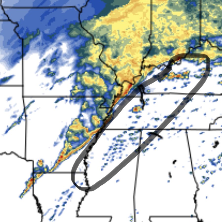
"HRRR shows a squall line with major renegade supercell potential in a dangerous environment out in front on afternoon of January 1. Tornado environment will advance east and a little northeast through overnight. Unfortunately target area is same areas impacted by Dec 10.outbreak"
-
Bgoney

- Tropical Storm
- Posts: 4966
- Joined: Fri Feb 26, 2021 7:09 pm
- Location: East clermont, 3mls north of Williamsburg
Re: January 2022 Weather Discussion
Finally the last day of our winterless December is here to put us out of our misery. Today and tomorrow of torch temps and then a week of temps somewhat closer to normal averaged out.
Mods have done very well with the upcoming system from a long ways out. Rain amounts for the region have been consistent the whole time. I think we have it covered nicely here. Sunday , a cold blustery snow showery kind of day along the river for bengals game. Happy NY. Go UC
Mods have done very well with the upcoming system from a long ways out. Rain amounts for the region have been consistent the whole time. I think we have it covered nicely here. Sunday , a cold blustery snow showery kind of day along the river for bengals game. Happy NY. Go UC
Proud owner of Best Guess Forecast Center (BGFC)
Former owner of Gut Feeling Forecast (GFF) and Doppler Infinity
Former owner of Gut Feeling Forecast (GFF) and Doppler Infinity
Re: January 2022 Weather Discussion
Good Morning and who gets the heaviest rain on New Years Day. That will happen probably rather close to the local area. Possible that somebody will get a months worth of rain in one day. That is probably near 3 inches in January. Still going with the 1-2 inches but as with most storms an area will get in the heaviest rainfall and 3 inches not out of the question. Grounds are not frozen and that helps with runoff but no doubt small creeks will rise and folks who live in those flood areas will need to be prepared as usual.
How quickly does the cold come in on Sunday morning is something we need to look at as roads will be wet. The good thing is with the temps on Saturday will keep the road temps up some but still need to see if some elevated roads get a little slick. I agree with Bgoney that Sunday looks like a true winters day with some snow showers around and a nice wind chill that could get in the teens at times. Does look like a weak low pressure will form on the front to our south. How strong will determine if we get in on a period of snow later Sunday. At this time the models have this to our southeast and folks closer to Lexington have a much better shot of getting in on some accumulation. Will need to watch this and the GOM has so much moisture available that models can underplay the amount of moisture available.
Next week is at least a more normal early January pattern and yes we still need to look for a system later in the week and models will get a better handle on that system once the current system heads out of our area.
I spoke to my neighbor who has a second home in Crested Butte,Co and is heading out today and he said they are making up for lost time in the snow department. He mentioned that the locals are even having a hard time keeping up the amount of snow on the roads and they have the greatest equipment but he is a skier and of course is very excited with the snow base he will have when he arrives,
-
tron777
- Major Hurricane
- Posts: 25378
- Joined: Fri Feb 26, 2021 5:10 pm
- Location: Burlington, KY
- Contact:
Re: January 2022 Weather Discussion
Good morning all and happy last day of 2021 to you all! To kick off the new year, I continue to watch our long term pattern and esp the 1/6 snow threat for the region is tops on my mind at this time. Overnight models showed the following:
0Z GFS - 2-4" NW of I-71 and 4-6" SE of I-71
6Z GFS: What storm?
0Z and 6Z GEFS: The usual range of solutions from this far out
0Z CMC: Strong cold frontal passage rain to snow and very windy
0Z Euro: All snow for the area: 0.30" QPF at CVG, 0.34" at DAY and 0.38" for CMH
The remainder of the long term looks cold with winter weather chances from time to time. Couldn't be happier attm with how things are looing to be honest. All I ask for are chances and some cold air and that looks to be the case thru mid January at this point in time. We'll see where the chips fall folks.
