Re: Atlantic Hurricane Season Discussion
Posted: Mon Jun 28, 2021 1:04 pm
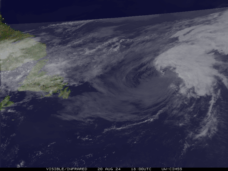
We have TD #4 now!
BULLETIN
Tropical Depression Four Advisory Number 1
NWS National Hurricane Center Miami FL AL042021
1100 AM EDT Mon Jun 28 2021
...NEW TROPICAL DEPRESSION FORMS OFF THE COAST OF SOUTH CAROLINA...
...TROPICAL STORM WARNING ISSUED FOR PORTIONS OF THE SOUTH
CAROLINA COAST...
SUMMARY OF 1100 AM EDT...1500 UTC...INFORMATION
-----------------------------------------------
LOCATION...31.9N 78.3W
ABOUT 145 MI...235 KM ESE OF BEAUFORT SOUTH CAROLINA
ABOUT 110 MI...180 KM ESE OF CHARLESTON SOUTH CAROLINA
MAXIMUM SUSTAINED WINDS...35 MPH...55 KM/H
PRESENT MOVEMENT...WNW OR 300 DEGREES AT 16 MPH...26 KM/H
MINIMUM CENTRAL PRESSURE...1013 MB...29.92 INCHES
WATCHES AND WARNINGS
--------------------
CHANGES WITH THIS ADVISORY:
A Tropical Storm Warning has been issued for a portion of the coast
of South Carolina from Edisto Beach northeastward to South Santee
River.
SUMMARY OF WATCHES AND WARNINGS IN EFFECT:
A Tropical Storm Warning is in effect for...
* Edisto Beach to South Santee River South Carolina
A Tropical Storm Warning means that tropical storm conditions are
expected somewhere within the warning area, in this case within the
next 12 hours.
For storm information specific to your area, including possible
inland watches and warnings, please monitor products issued by your
local National Weather Service forecast office.
DISCUSSION AND OUTLOOK
----------------------
At 1100 AM EDT (1500 UTC), the center of Tropical Depression Four
was located near latitude 31.9 North, longitude 78.3 West. The
depression is moving toward the west-northwest near 16 mph (26 km/h)
and this general motion is expected to continue for the next couple
of days. On the forecast track, the center of the tropical cyclone
should make landfall along coast of South Carolina in the warning
area later this evening.
Maximum sustained winds are near 35 mph (55 km/h) with higher gusts.
Some slight strengthening is expected today, and the depression is
forecast to become a tropical storm before it makes landfall. Rapid
weakening is forecast after landfall occurs.
The estimated minimum central pressure is 1013 mb (29.92 inches).
HAZARDS AFFECTING LAND
----------------------
Key messages for Tropical Depression Four can be found in the
Tropical Cyclone Discussion under AWIPS header MIATCDAT4, WMO header
WTNT44 KNHC and on the web at
www.hurricanes.gov/graphics_at4.shtml?key_messages.
WIND: Tropical storm conditions are expected to first reach
the coast within the warning area by late this afternoon, making
outside preparations difficult or dangerous.
RAINFALL: The depression could produce 1 to 3 inches of rainfall
with locally higher amounts along the immediate coasts of Georgia
and southern South Carolina. This region has been dry, limiting
potential widespread flooding impacts, however, local flooding
impacts, especially in urban areas along the southern South Carolina
and Georgia coasts, cannot be ruled out at this time.
Farther inland, 1 to 2 inches of rainfall is possible across Upstate
South Carolina, the Piedmont of Georgia, and into northeastern
Alabama.
STORM SURGE: The combination of storm surge and the tide will cause
normally dry areas near the coast to be flooded by rising waters
moving inland from the shoreline. The water could reach the
following heights above ground somewhere in the indicated areas if
the peak surge occurs at the time of high tide...
Port Royal Sound, SC to South Santee River, SC...1 to 3 ft
Surge-related flooding depends on the relative timing of the surge
and the tidal cycle, and can vary greatly over short distances. For
information specific to your area, please see products issued by
your local National Weather Service forecast office.
NEXT ADVISORY
-------------
Next intermediate advisory at 200 PM EDT.
Next complete advisory at 500 PM EDT.