Good Evening and its fun to watch met's see the items we see on here though we often see those items before they do. Good to know though we are looking at the correct information
Re: February 2025 Weather Discussion
Posted: Thu Feb 13, 2025 7:09 pm
by tpweather
Just looking over some items this evening and 1-2 inches seems correct for our area. Probably .5-.75 for the early round and then taper off until the next round comes later in the day. I still believe the heaviest rains will be well south of our area though I guess the southeast portion of our area could see over 2 inches. Much of Kentucky though could see between 2-4 inches and yes somewhere that a heavier band gets stuck for several hours some 5 and probably 6 inch totals. Getting the warmth from the south and the cold coming out of the northwest these do collide and fight it out for a period and you can get rainfall rates over 1 inch an hour with no problems.
Next question is how quick the cold air settles in. Problem is with rain most of the day you need several hours of a strong wind to help dry up the streets. Plus with us not sure how high we go temperature wise on Saturday. Do we stay in the 30's all day or do we have a 6 hour period where we get into the mid 40's. I am going lower just because I believe that is how its going to play out. Then do we get below 32 before the streets are dry and if so I can sees some flash freezing possible. During the day Sunday some decent snow showers and temps falling so once again especially after 3pm or so roads can become slick again and temps are taking a dive and will be in the teens Monday Morning.
So that is it so far and really just started to look at next week as we have moving parts once again and my guess several changes on the models over the next 3 days concerning next week.
Re: February 2025 Weather Discussion
Posted: Thu Feb 13, 2025 9:37 pm
by Bgoney
I don’t know, seeing a trend in models of a more west low shift. Seeing more 2-3+ amounts for cvgland and 2-4+ for SE counties
Re: February 2025 Weather Discussion
Posted: Fri Feb 14, 2025 4:28 am
by tron777
Good morning and Bgoney is right. Flood watch has been expanded more to the NW now to include the Tri-state.
/00000.0.ER.000000T0000Z.000000T0000Z.000000T0000Z.OO/
Ohio-Switzerland-Carroll-Gallatin-Boone-Kenton-Campbell-Ross-
Hocking-Hamilton-Clermont-Highland-
Including the cities of Alexandria, Independence, Florence, Mount
Repose, Day Heights, Hillsboro, Oakbrook, Greenfield, Erlanger,
Logan, Mulberry, Rising Sun, Withamsville, Burlington, Downtown
Cincinnati, Dayton, Newport, Carrollton, Covington, Mount Carmel,
Warsaw, Summerside, Fort Thomas, Highland Heights, Milford,
Chillicothe, Bellevue, and Vevay
200 AM EST Fri Feb 14 2025
...FLOOD WATCH IN EFFECT FROM SATURDAY AFTERNOON THROUGH SUNDAY
AFTERNOON...
* WHAT...Flooding caused by excessive rainfall continues to be
possible.
* WHERE...The following counties, in southeast Indiana, Ohio and
Switzerland, the following counties, in northern Kentucky, Boone,
Campbell, Carroll, Gallatin and Kenton, and the following
counties, in Ohio, Clermont, Hamilton, Highland, Hocking and Ross.
* WHEN...From Saturday afternoon through Sunday afternoon.
* IMPACTS...Excessive runoff may result in flooding of rivers,
creeks, streams, and other low-lying and flood-prone locations.
Re: February 2025 Weather Discussion
Posted: Fri Feb 14, 2025 4:34 am
by tron777
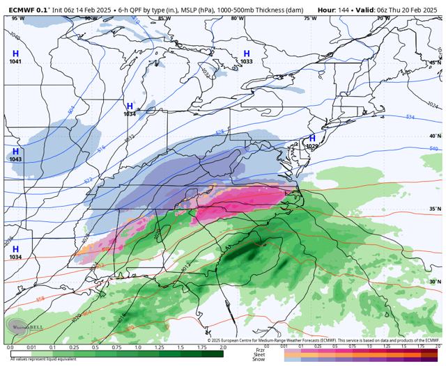
For next week, models blow this system up for the East Coast and depending on how quick it gets its act together will determine how much QPF we get. We could see two periods of snow. Tues night into Wed then again Wed night into Thurs.
Re: February 2025 Weather Discussion
Posted: Fri Feb 14, 2025 5:39 am
by tron777
6Z GFS is an interesting solution.... we get 0.22" from the first wave of snow next week, then as the trough goes negative tilt Wed night into Thurs, we get another 0.11" or so with the upper level energy. With the cold temps and that much QPF, it would be a 4-5" type of snowfall. Def need to keep an eye on it. Again.. how long it takes this storm to develop as well as 2 pieces of energy or just one, will make a huge difference in the amount of QPF we get.
Re: February 2025 Weather Discussion
Posted: Fri Feb 14, 2025 5:56 am
by Bgoney
A warm February start for parts of Alaska
Nome's mean temperature is running at second warmest on record both since November 1 and since December 1.
About a third of days since December 1 have seen a high temperature at or above freezing - including the last 3 days, and 7 of 12 days so far this month!
In Anchorage, it's a top-10 warm winter so far, but the lack of snow is the real story. With only 4.3 inches of snow since December 1, it's the least snowy winter (Dec-Feb) on record so far
Re: February 2025 Weather Discussion
Posted: Fri Feb 14, 2025 6:04 am
by tron777
I checked the Ensembles for next week and both the 6Z GEFS and 0Z EPS are a bit wetter with QPF versus their previous runs. We are very close to a big dog event. Just need things to come together a little sooner then what is currently being shown and then we're in! Odds are right now that we will see a light to moderate event. A big dog event is low... looks better for the East Coast and interior New England. However, there are still plenty of time for things to change thru this weekend. We should start to see some model agreement by then with how this storm comes together. Before we get there, a lot of rain to track and even some snow showers on Sunday! Buckle up folks!
Re: February 2025 Weather Discussion
Posted: Fri Feb 14, 2025 6:28 am
by tron777
I hope the below link works (I stole this from American Wx) Assuming this works, you can see on the 6Z Euro for next week how close we are to a big one.
Good Morning and no doubt the models are moving northwest with the low later Saturday. Will watch this unfold today and no doubt somebody going to get hit hard and should be a thin area probably 50 miles wide that could get into that 5 or 6 inch range wow. Still keeping my forecast the same and will start to see what the shorter term models are showing.
Concerning next week and yes some snow will fly but will we get a bigger system mid-week. Depends if we can get the pieces of energy to get together. Will be watching for the upper lows hanging around next week because these are keys for not only getting a stronger storm but also having the system further west. Still too early on this forecast and again models will do the old Icky Shuffle until probably Monday after the big storm this weekend as left the building.
COLD starting Sunday and that will be around for at least 10 days. Winter is not letting up so staying busy on here is going to happen
Re: February 2025 Weather Discussion
Posted: Fri Feb 14, 2025 7:05 am
by tpweather
More posts today and the warm front that will be to the south on Saturday will start moving northward. Earlier this week many models had this getting to central Kentucky and stalling. The problem for us is it looks like the front will head further north bringing heavier rain further north. When and where does the front stop moving northward and how long will the front sort of stall is key in getting larger totals. The push of cold behind this system is strong as well with temps in the teens by Monday morning. Will probably need to update my totals locally and going to be a general rain total but with a note that somewhere in a small area say 50 miles wide could exceed the higher totals. My guess will update my forecast after the noon runs and make sure the northward push is still there but no matter what I could see Saturday as one of the higher totals in February for rain amounts in a day.
Re: February 2025 Weather Discussion
Posted: Fri Feb 14, 2025 7:22 am
by tron777
13 this morning IMBY and at CVG. That's impressive for mid Feb and the fact that most of the snow is gone.
Re: February 2025 Weather Discussion
Posted: Fri Feb 14, 2025 7:26 am
by MVWxObserver
10 here in G'ville and progged to top out at around the freezing mark.
Re: February 2025 Weather Discussion
Posted: Fri Feb 14, 2025 8:24 am
by tron777
Re: February 2025 Weather Discussion
Posted: Fri Feb 14, 2025 10:06 am
by tron777
BG's video already in progress...
Re: February 2025 Weather Discussion
Posted: Fri Feb 14, 2025 11:24 am
by tron777
12Z GFS bumped SE which doesn't change the rainfall amounts that much, but it does give us a better shot at backend snows on Sunday with regards to receiving some light accumulations. For next week, the energy is more disjointed then previous runs so we still get some accumulating snow Tues night into Wed then on Thurs some snow showers with the upper low. so far, the foreign models have shown a more well developed system. We'll see if that holds today or not. 12Z CMC is still showing a bigger system. Light snow Tues night then more light snow Wed night into Thurs as the main system for the EC gets going. I would like to see this system get its act together about 12 hours sooner then we'd get crushed.
Re: February 2025 Weather Discussion
Posted: Fri Feb 14, 2025 11:50 am
by tron777
12Z GEFS for next week continues to bump up the QPF ever so slightly with each passing run. IMO that is a nod to the CMC and Euro solutions. The more disjointed OP GFS is the outlier solution at the moment.
Re: February 2025 Weather Discussion
Posted: Fri Feb 14, 2025 11:59 am
by tron777
Add the 12Z UKMET to the list of possible snow makers for next week. Looks a lot like the Canadian. Hope to see a decent Euro run here soon too.
Re: February 2025 Weather Discussion
Posted: Fri Feb 14, 2025 1:03 pm
by tron777
12Z Euro gives CVG 0.04" of QPF on Tues then another 0.10" later Tues night and Wed when the storm starts to get going for the East Coast. 0.03" for Thurs with the leftovers on the back side. Not as good of a run for us as previous runs due to the system getting sheared out for the OV.
Re: February 2025 Weather Discussion
Posted: Fri Feb 14, 2025 2:19 pm
by tpweather
Good Afternoon and still looking at the new data and will make my final call on the weekend storm hopefully later today. Next week tons of cold and plenty of energy but to really get a bigger storm we need a nice upper low to move out of the northern plains and merge with moisture that will no doubt be available. If that can happen somewhere over the Mississippi Valley then this would allow for a storm to move more southwest to northeast instead of a straight eastward push. Still believe once this system over the weekend is out of the USA we can get a better handle of where different pieces of energy will be located push the push of cold and where high pressure will try and park itself for a few days. Again its way to early and first I will try and get the weekend forecast correct though going to be a forecast with some if this happens or if this happens here is the outcome. Hopefully by later today I will have my forecast ready to go
Re: February 2025 Weather Discussion
Posted: Fri Feb 14, 2025 2:37 pm
by tron777
I agree Tim... it should be easy to make a weekend forecast now but for next week, probably cant until Sunday or Pres Day.
Re: February 2025 Weather Discussion
Posted: Fri Feb 14, 2025 3:53 pm
by tpweather
Back in the saddle and ready to sit down and start looking at the rain event ready to unfold. I have no ideal what the highest totals for rain is in one day for February but my guess Saturday the 15th could end up in the top 5. After the new info which really has not changed much since overnight I had to up the totals and go with a general 2-4 inches locally. Does the rain stop for a few hours in the afternoon over the northern area and that is very possible and that could keep those folks on the lower end. Where the rain never quits 4 inches is possible and again somebody will get in that 5 or 6inch range once we see exactly where the band of heaviest rain sets up on Saturday. That is something we will need to watch and even short term models can have problems this far out to hit that exactly correct.
Then a very strong cold front pushes through and temps fall quickly. How quickly do they fall to the 32 degree mark and will the wind be able to dry many roads before they ice over. Will be tricky and though probably not a widespread issue with that amount of rain some ice will no doubt form on some streets. Then some decent snow showers on Sunday and later in the day and early evening would not be surprised to see some minor accumulations though the main problem will be the cold and any snow can create more icy roads that evening into Monday morning.
So that is how I see the weekend and again will be a nowcast on Saturday because this is a rather big event for mid-Feb.