We need to start seeing at least one or two WWBs this winter or early spring to get there
January 2023 Weather Discussion
-
Bgoney

- Hurricane
- Posts: 5056
- Joined: Fri Feb 26, 2021 7:09 pm
- Location: East clermont, 3mls north of Williamsburg
Re: January 2023 Weather Discussion
Proud owner of Best Guess Forecast Center (BGFC)
Former owner of Gut Feeling Forecast (GFF) and Doppler Infinity
Former owner of Gut Feeling Forecast (GFF) and Doppler Infinity
-
tron777

- Major Hurricane
- Posts: 25791
- Joined: Fri Feb 26, 2021 5:10 pm
- Location: Burlington, KY
- Contact:
Re: January 2023 Weather Discussion

-
Bgoney
- Hurricane
- Posts: 5056
- Joined: Fri Feb 26, 2021 7:09 pm
- Location: East clermont, 3mls north of Williamsburg
Re: January 2023 Weather Discussion
Been thinking about those crazy SOIs. That has to be a case where the SOI is playing catch up (lag) to a waning LANINAtron777 wrote: ↑Wed Jan 04, 2023 8:32 amI'd also like to start seeing the SOI dropping into negative territory here pretty soon too. That would be another good sign if it were to occur.
. I know when they were in the 50+ range there was a TC in the area to skew to a high number. I do expect less big +numbers to commense shortly
Proud owner of Best Guess Forecast Center (BGFC)
Former owner of Gut Feeling Forecast (GFF) and Doppler Infinity
Former owner of Gut Feeling Forecast (GFF) and Doppler Infinity
-
tron777
- Major Hurricane
- Posts: 25791
- Joined: Fri Feb 26, 2021 5:10 pm
- Location: Burlington, KY
- Contact:
Re: January 2023 Weather Discussion
I agree. We've pointed out already that this Nina is not behaving like a Nina. We are seeing the warming occurring in the SST's from the East regions 1.2 along with 3 and 3.4 have warmed a bit. Region 4 (West PAC) has still not responded, as in still pretty cold! Will that continue the MJO fail or can the current impulse finally break thru into the West Pac ala Phase 8? MJO modeling has it getting into Phase 8 after 1/10. Virtually all guidance is now showing this. It could easily fail, we've seen it before.Bgoney wrote: ↑Wed Jan 04, 2023 8:51 amBeen thinking about those crazy SOIs. That has to be a case where the SOI is playing catch up (lag) to a waning LANINAtron777 wrote: ↑Wed Jan 04, 2023 8:32 amI'd also like to start seeing the SOI dropping into negative territory here pretty soon too. That would be another good sign if it were to occur.
. I know when they were in the 50+ range there was a TC in the area to skew to a high number. I do expect less big +numbers to commense shortly
-
BookNerdCarp

- EF1 Tornado
- Posts: 420
- Joined: Fri Feb 26, 2021 5:57 pm
Re: January 2023 Weather Discussion
Been a wet couple days IMBY
*_*_*_*_*_*_*_*_*_*_*_*_*_*_*_*_*_*_*_*_*_*
Ripley, OH (Brown County)
Home of the "Cold Rain Haters"
*_*_*_*_*_*_*_*_*_*_*_*_*_*_*_*_*_*_*_*_*_*
Ripley, OH (Brown County)
Home of the "Cold Rain Haters"
*_*_*_*_*_*_*_*_*_*_*_*_*_*_*_*_*_*_*_*_*_*
-
tron777
- Major Hurricane
- Posts: 25791
- Joined: Fri Feb 26, 2021 5:10 pm
- Location: Burlington, KY
- Contact:
Re: January 2023 Weather Discussion
Wow... Very hefty totals Matt! I saw on the KY Mesonet site, where over 5" of rain fell in LOU's CWA over the last 24 to 36 hours. I believe CB's overnight blog had a pic of that listed.
-
tron777
- Major Hurricane
- Posts: 25791
- Joined: Fri Feb 26, 2021 5:10 pm
- Location: Burlington, KY
- Contact:
Re: January 2023 Weather Discussion
This ties in pretty well with our ongoing SOI and MJO discussion. Could we see the SOI start to drop around or just after the 10th? Are the models correct with the MJO moving along and getting into Phase 8 after the 10th? The overnight EPS Mean show some nice subsidence around that time:
OP GFS:
OP GFS:
You do not have the required permissions to view the files attached to this post.
Re: January 2023 Weather Discussion
was surprised how warm it was earlier. approaching record high temps for today. wow . good thing its not gonna last too long though as we will have more seasonal cold come back by the weekend. temps looks to be around average or just above for the next 10 days or so.
22'/23' snowfall > 11"
23'/24' snowfall > 19.5"
24'/25' snowfall > 24 "
23'/24' snowfall > 19.5"
24'/25' snowfall > 24 "
-
tron777
- Major Hurricane
- Posts: 25791
- Joined: Fri Feb 26, 2021 5:10 pm
- Location: Burlington, KY
- Contact:
Re: January 2023 Weather Discussion
We are expecting the same here locally. The cold front which will bring in the more avg to slightly above avg airmass, has passed Cincinnati and is moving into our Eastern counties now. Even some sunshine here behind the front. Not too bad of a day now until temps drop off thru the 50s as the afternoon wears on.airwolf76 wrote: ↑Wed Jan 04, 2023 10:45 am was surprised how warm it was earlier. approaching record high temps for today. wow . good thing its not gonna last too long though as we will have more seasonal cold come back by the weekend. temps looks to be around average or just above for the next 10 days or so.
Re: January 2023 Weather Discussion
starting t o wonder if this will be a 1996 type la-nina winter. back then it was a flip flop pattern every 3 weeks or so. we started of Jan very cold and a blizzard 1 week in, towards then end of that same month was 50s and tons of rain and flooding and then we have a very cold and snowy period in February. I am thinking this winter is going to go back and forth every 2-3 weeks or so. pretty much what we have already seen this fall/winter quite franklytron777 wrote: ↑Wed Jan 04, 2023 10:52 amWe are expecting the same here locally. The cold front which will bring in the more avg to slightly above avg airmass, has passed Cincinnati and is moving into our Eastern counties now. Even some sunshine here behind the front. Not too bad of a day now until temps drop off thru the 50s as the afternoon wears on.airwolf76 wrote: ↑Wed Jan 04, 2023 10:45 am was surprised how warm it was earlier. approaching record high temps for today. wow . good thing its not gonna last too long though as we will have more seasonal cold come back by the weekend. temps looks to be around average or just above for the next 10 days or so.
22'/23' snowfall > 11"
23'/24' snowfall > 19.5"
24'/25' snowfall > 24 "
23'/24' snowfall > 19.5"
24'/25' snowfall > 24 "
-
tron777
- Major Hurricane
- Posts: 25791
- Joined: Fri Feb 26, 2021 5:10 pm
- Location: Burlington, KY
- Contact:
Re: January 2023 Weather Discussion
A cold and / or snowy February would not shock me. We've had our best wintry events in Feb since this Triple Dip Nina began.airwolf76 wrote: ↑Wed Jan 04, 2023 11:22 amstarting t o wonder if this will be a 1996 type la-nina winter. back then it was a flip flop pattern every 3 weeks or so. we started of Jan very cold and a blizzard 1 week in, towards then end of that same month was 50s and tons of rain and flooding and then we have a very cold and snowy period in February. I am thinking this winter is going to go back and forth every 2-3 weeks or so. pretty much what we have already seen this fall/winter quite franklytron777 wrote: ↑Wed Jan 04, 2023 10:52 amWe are expecting the same here locally. The cold front which will bring in the more avg to slightly above avg airmass, has passed Cincinnati and is moving into our Eastern counties now. Even some sunshine here behind the front. Not too bad of a day now until temps drop off thru the 50s as the afternoon wears on.airwolf76 wrote: ↑Wed Jan 04, 2023 10:45 am was surprised how warm it was earlier. approaching record high temps for today. wow . good thing its not gonna last too long though as we will have more seasonal cold come back by the weekend. temps looks to be around average or just above for the next 10 days or so.
-
Bgoney
- Hurricane
- Posts: 5056
- Joined: Fri Feb 26, 2021 7:09 pm
- Location: East clermont, 3mls north of Williamsburg
Re: January 2023 Weather Discussion
61 at work with mostly sunny skys
Proud owner of Best Guess Forecast Center (BGFC)
Former owner of Gut Feeling Forecast (GFF) and Doppler Infinity
Former owner of Gut Feeling Forecast (GFF) and Doppler Infinity
-
Bgoney
- Hurricane
- Posts: 5056
- Joined: Fri Feb 26, 2021 7:09 pm
- Location: East clermont, 3mls north of Williamsburg
Re: January 2023 Weather Discussion
For a second half of January save it has to get to 8 to change up the 500mb PACtron777 wrote: ↑Wed Jan 04, 2023 10:33 am This ties in pretty well with our ongoing SOI and MJO discussion. Could we see the SOI start to drop around or just after the 10th? Are the models correct with the MJO moving along and getting into Phase 8 after the 10th? The overnight EPS Mean show some nice subsidence around that time:
EPSVerticalVelocity.png
OP GFS:
OPGFSVerticalVelocity.gif
Proud owner of Best Guess Forecast Center (BGFC)
Former owner of Gut Feeling Forecast (GFF) and Doppler Infinity
Former owner of Gut Feeling Forecast (GFF) and Doppler Infinity
-
tron777
- Major Hurricane
- Posts: 25791
- Joined: Fri Feb 26, 2021 5:10 pm
- Location: Burlington, KY
- Contact:
Re: January 2023 Weather Discussion
Completely agree. We'll see over the next week what happens. We'll know next week I would suspect if this has a legit shot of happening or is it another failure which won't shock us. The shocker would be if it actually gets into 8.Bgoney wrote: ↑Wed Jan 04, 2023 11:29 amFor a second half of January save it has to get to 8 to change up the 500mb PACtron777 wrote: ↑Wed Jan 04, 2023 10:33 am This ties in pretty well with our ongoing SOI and MJO discussion. Could we see the SOI start to drop around or just after the 10th? Are the models correct with the MJO moving along and getting into Phase 8 after the 10th? The overnight EPS Mean show some nice subsidence around that time:
EPSVerticalVelocity.png
OP GFS:
OPGFSVerticalVelocity.gif
-
Bgoney
- Hurricane
- Posts: 5056
- Joined: Fri Feb 26, 2021 7:09 pm
- Location: East clermont, 3mls north of Williamsburg
Re: January 2023 Weather Discussion
One thing that is encouraging is that we are seeing the westerly anomalies reach further east (closer to dateline), than I've seen for quite sometime and are modeled to continue, possibly giving a boost for the MJO to trek into 8 instead of dieing in 8. Also think those westerly anomalies advancing into the west pac have been what has given the PACJET a steroid effect and the coast enjoying drought busting qpftron777 wrote: ↑Wed Jan 04, 2023 11:33 amCompletely agree. We'll see over the next week what happens. We'll know next week I would suspect if this has a legit shot of happening or is it another failure which won't shock us. The shocker would be if it actually gets into 8.Bgoney wrote: ↑Wed Jan 04, 2023 11:29 amFor a second half of January save it has to get to 8 to change up the 500mb PACtron777 wrote: ↑Wed Jan 04, 2023 10:33 am This ties in pretty well with our ongoing SOI and MJO discussion. Could we see the SOI start to drop around or just after the 10th? Are the models correct with the MJO moving along and getting into Phase 8 after the 10th? The overnight EPS Mean show some nice subsidence around that time:
EPSVerticalVelocity.png
OP GFS:
OPGFSVerticalVelocity.gif
You do not have the required permissions to view the files attached to this post.
Proud owner of Best Guess Forecast Center (BGFC)
Former owner of Gut Feeling Forecast (GFF) and Doppler Infinity
Former owner of Gut Feeling Forecast (GFF) and Doppler Infinity
-
tron777
- Major Hurricane
- Posts: 25791
- Joined: Fri Feb 26, 2021 5:10 pm
- Location: Burlington, KY
- Contact:
Re: January 2023 Weather Discussion
Definitely an encouraging sign! the GFS in the long term today has a workable pattern from around mid month and beyond. Could it be that maybe it is seeing the more favorable MJO phase taking place? Or is it just sniffing glue like usual?Bgoney wrote: ↑Wed Jan 04, 2023 11:55 am One thing that is encouraging is that we are seeing the westerly anomalies reach further east (closer to dateline), than I've seen for quite sometime and are modeled to continue, possibly giving a boost for the MJO to trek into 8 instead of dieing in 8. Also think those westerly anomalies advancing into the west pac have been what has given the PACJET a steroid effect and the coast enjoying drought busting qpf
u.anom.30.5S-5N.gif
-
Bgoney
- Hurricane
- Posts: 5056
- Joined: Fri Feb 26, 2021 7:09 pm
- Location: East clermont, 3mls north of Williamsburg
Re: January 2023 Weather Discussion
I'm going to keep going on the subject , lol.. we've talked about lag time lately and I think this gets passed over alot by many mets on webdom. We got into phase 5 give or take around the 20th-22nd. The lower 48 started the warm pattern 5-7 days later ,roughly . So IF we do get to phase 8 to some degree can we expect that same lag time for a return to some semblance of Arctic air?tron777 wrote: ↑Wed Jan 04, 2023 11:59 amDefinitely an encouraging sign! the GFS in the long term today has a workable pattern from around mid month and beyond. Could it be that maybe it is seeing the more favorable MJO phase taking place? Or is it just sniffing glue like usual?Bgoney wrote: ↑Wed Jan 04, 2023 11:55 am One thing that is encouraging is that we are seeing the westerly anomalies reach further east (closer to dateline), than I've seen for quite sometime and are modeled to continue, possibly giving a boost for the MJO to trek into 8 instead of dieing in 8. Also think those westerly anomalies advancing into the west pac have been what has given the PACJET a steroid effect and the coast enjoying drought busting qpf
u.anom.30.5S-5N.gif
Proud owner of Best Guess Forecast Center (BGFC)
Former owner of Gut Feeling Forecast (GFF) and Doppler Infinity
Former owner of Gut Feeling Forecast (GFF) and Doppler Infinity
-
tron777
- Major Hurricane
- Posts: 25791
- Joined: Fri Feb 26, 2021 5:10 pm
- Location: Burlington, KY
- Contact:
Re: January 2023 Weather Discussion
You are always bringing up great points and this is another. I have been guilty of rushing pattern changes and we know the models are notorious for doing it so that could certainly explain why we see these things happen. So if we use this logic, for example, if the MJO gets into Phase 8 by the 10th, apply the lag time and we should see a colder pattern emerge by the 15th-17th. I know Tim and I have been discussing a change from seasonal temps, which we know are coming after today to a better pattern for snow lovers around mid moth so our thoughts are not way off at all on this. We are all on the same page with arctic air. No one on our forum (as far as I know) currently expects a return to what we saw for Christmas. If we can manage some 20s and 30s during the back half of the month, we'll be off and running!Bgoney wrote: ↑Wed Jan 04, 2023 1:05 pmI'm going to keep going on the subject , lol.. we've talked about lag time lately and I think this gets passed over alot by many mets on webdom. We got into phase 5 give or take around the 20th-22nd. The lower 48 started the warm pattern 5-7 days later ,roughly . So IF we do get to phase 8 to some degree can we expect that same lag time for a return to some semblance of Arctic air?tron777 wrote: ↑Wed Jan 04, 2023 11:59 amDefinitely an encouraging sign! the GFS in the long term today has a workable pattern from around mid month and beyond. Could it be that maybe it is seeing the more favorable MJO phase taking place? Or is it just sniffing glue like usual?Bgoney wrote: ↑Wed Jan 04, 2023 11:55 am One thing that is encouraging is that we are seeing the westerly anomalies reach further east (closer to dateline), than I've seen for quite sometime and are modeled to continue, possibly giving a boost for the MJO to trek into 8 instead of dieing in 8. Also think those westerly anomalies advancing into the west pac have been what has given the PACJET a steroid effect and the coast enjoying drought busting qpf
u.anom.30.5S-5N.gif
-
tron777
- Major Hurricane
- Posts: 25791
- Joined: Fri Feb 26, 2021 5:10 pm
- Location: Burlington, KY
- Contact:
Re: January 2023 Weather Discussion
12Z Euro also looking more interesting in its extended range today. What looks like a Cutter to Chicago, runs into a blocking 1044 MB high anchored over S Ontario just N of the Great Lakes. The low is forced SE under the block into West KY and TN. That low eventually weakens with a new low forming over SE Georgia. which moves off the coast to produce some snow in the Carolinas. All fantasy talk right now but the point here is that we have seen some nice trends today on models. Hopefully, that continues in the coming days.
-
tron777
- Major Hurricane
- Posts: 25791
- Joined: Fri Feb 26, 2021 5:10 pm
- Location: Burlington, KY
- Contact:
Re: January 2023 Weather Discussion
CVG maxed out at 62. Down to 57 now as of 2pm as the cooler air is finally starting to move in.
Re: January 2023 Weather Discussion
Good Afternoon and just got home from a busy day for me and starting to look over everything. First I will start posting in the correct place for the upcoming weekend and then back here for longer term forecasts.
Re: January 2023 Weather Discussion
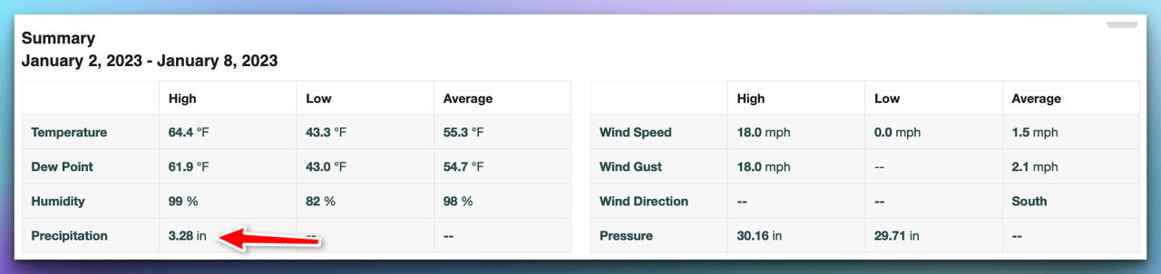
I really did not want to put this in the December thread so for the year at CVG we ended up .02 degrees above normal and precip wise we ended up a little over 3 inches above normal. So this will go down as a normal year in terms of temperature and slightly above normal in precip. We had the mini-drought late in the summer and fall along with some decent warm spells in November and December but once you get the full scope of the year it was rather average. I know the Indy NWS the other day mentioned they had one of the driest years in many years and I believe they had 34 or 35 inches which is below normal but not by much. I try to put everything in prospective and sure it was dry but not unusual imo.
Re: January 2023 Weather Discussion
Very interesting on the models later next week. Still believe somewhere in the middle of the month we see a big storm in the east that is a forerunner to a colder pattern. The Euro has a system later next week and with a low to the south of us but a rather strong high northeast of us. I know I have been touting eastern Canada and how that part of the world and how its getting colder can have an impact on us towards mid-month. This happens more in February but can happen anytime in the winter season. These highs get really strong and they expand towards the south and west. When this happens then you see a system to the south that throws moisture northward and you get these wonderful overriding events which depending how deep you are in the cold air will make a difference on precip type including sleet and fr/rain. Very early on this storm system and no prediction this far in advance but the pattern fits a system like this to develop. Once we get into spring that part of Canada is last to warm up and you will see snows in New England in May and even June because of the cold that remains in eastern Canada. So will keep an eye on late next week and way too early to make a storm threat but I could see one by early next week for a late week storm.
Re: January 2023 Weather Discussion
Before I forget we could see a few flurries or even a quick snow shower later Thursday into early Friday. Ground is warm and even with a quick snow shower the best you would see is a little snow on the grass. This system to the north looks to be moving out a tad quicker than models showed yesterday and this also gives us a little more ridging Friday and Saturday and this could deepen up the system in the central plains a tad more before moving eastward. Again this is a small system and moisture is still limited but if someone in the Ohio Valley is north of the low you can get a few inches of snow. I will continue this talk in the storm thread but the earlier system can have some ramifications on the weekend system
-
Bgoney
- Hurricane
- Posts: 5056
- Joined: Fri Feb 26, 2021 7:09 pm
- Location: East clermont, 3mls north of Williamsburg
Re: January 2023 Weather Discussion
Next 10 days or so of qpf for SoCal. (EPS) That's some 6-9" around LA. They should be able to flush their toilets again..
You do not have the required permissions to view the files attached to this post.
Proud owner of Best Guess Forecast Center (BGFC)
Former owner of Gut Feeling Forecast (GFF) and Doppler Infinity
Former owner of Gut Feeling Forecast (GFF) and Doppler Infinity
