One of his friends is stuck in a van in a ditch an hour outside Union, KY trying to come back from Boy Scout camp, waiting for a tow.
Sunday Wet Snow Thump 1/22/23
-
MJSun

- Thunder Storm
- Posts: 253
- Joined: Fri Feb 26, 2021 7:42 pm
- Location: Batavia Tshp (h)/Norwood (w)
Re: Sunday Wet Snow Thump 1/22/23
Still lightly falling on East side. Oldest kid's basketball game just got cancelled too.
One of his friends is stuck in a van in a ditch an hour outside Union, KY trying to come back from Boy Scout camp, waiting for a tow.
One of his friends is stuck in a van in a ditch an hour outside Union, KY trying to come back from Boy Scout camp, waiting for a tow.
You do not have the required permissions to view the files attached to this post.
Last edited by MJSun on Sun Jan 22, 2023 11:51 am, edited 2 times in total.
Mollie
Cincinnati: Batavia/Amelia (H), Norwood (W)
The extent of my weather knowledge is pointing at the sky and saying what color it is.

Cincinnati: Batavia/Amelia (H), Norwood (W)
The extent of my weather knowledge is pointing at the sky and saying what color it is.
-
tron777

- Major Hurricane
- Posts: 25387
- Joined: Fri Feb 26, 2021 5:10 pm
- Location: Burlington, KY
- Contact:
Re: Sunday Wet Snow Thump 1/22/23
I appreciate everyone's pics, obs, and reports today! Outstanding job by all of you! Tim, I'll probably wait for the Euro / EPS before making the thread. I need to shovel as well and will be heading outside myself here shortly. 33 degrees here with the snow just barely still falling at this time so she is in the process of wrapping up!

-
MJSun
- Thunder Storm
- Posts: 253
- Joined: Fri Feb 26, 2021 7:42 pm
- Location: Batavia Tshp (h)/Norwood (w)
Re: Sunday Wet Snow Thump 1/22/23
ILN:
WARNING- IT ALREADY SNOWED!! TAKE PRECAUTIO... TAKE CAUTIONS.
Mollie
Cincinnati: Batavia/Amelia (H), Norwood (W)
The extent of my weather knowledge is pointing at the sky and saying what color it is.
Cincinnati: Batavia/Amelia (H), Norwood (W)
The extent of my weather knowledge is pointing at the sky and saying what color it is.
-
MVWxObserver
- Hurricane
- Posts: 6893
- Joined: Fri Feb 26, 2021 7:48 pm
- Location: Greenville, OH
Re: Sunday Wet Snow Thump 1/22/23
Hey Mollie,MJSun wrote: ↑Sun Jan 22, 2023 9:24 am Smaller flakes, still falling. Husband went to pick up youngest from a sleepover so curious to hear about roads. He's been up and about for a while (morning person) and in his truck.
Curious to see if Oldest kid's basket game still on at 3p. My guess is probably. At least it's at one of the closest schools to our house.
The very best to your son and his ball team if its on for today!
Maybe you can watch some of the Bengals game on an app at your son's game, too!
At the freezing mark with light snow here in Greenville. Will take a measurement between lunch and 3 o'clock.
Eric
Greenville, OH
Greenville, OH
-
MJSun
- Thunder Storm
- Posts: 253
- Joined: Fri Feb 26, 2021 7:42 pm
- Location: Batavia Tshp (h)/Norwood (w)
Re: Sunday Wet Snow Thump 1/22/23
Thanks! We just heard it got cancelled so we can stay home to watch the game, at least until we head to my MIL's house for dinner. It's only a few minutes away so it should be fine.MVWxObserver wrote: ↑Sun Jan 22, 2023 11:50 amHey Mollie,MJSun wrote: ↑Sun Jan 22, 2023 9:24 am Smaller flakes, still falling. Husband went to pick up youngest from a sleepover so curious to hear about roads. He's been up and about for a while (morning person) and in his truck.
Curious to see if Oldest kid's basket game still on at 3p. My guess is probably. At least it's at one of the closest schools to our house.
The very best to your son and his ball team if its on for today!Also to the Bengals!
Maybe you can watch some of the Bengals game on an app at your son's game, too!
At the freezing mark with light snow here in Greenville. Will take a measurement between lunch and 3 o'clock.
Mollie
Cincinnati: Batavia/Amelia (H), Norwood (W)
The extent of my weather knowledge is pointing at the sky and saying what color it is.
Cincinnati: Batavia/Amelia (H), Norwood (W)
The extent of my weather knowledge is pointing at the sky and saying what color it is.
-
BookNerdCarp

- EF1 Tornado
- Posts: 416
- Joined: Fri Feb 26, 2021 5:57 pm
Re: Sunday Wet Snow Thump 1/22/23
My son in West Chester (sorry didn't have time to rotate image)
*_*_*_*_*_*_*_*_*_*_*_*_*_*_*_*_*_*_*_*_*_*
Ripley, OH (Brown County)
Home of the "Cold Rain Haters"
*_*_*_*_*_*_*_*_*_*_*_*_*_*_*_*_*_*_*_*_*_*
Ripley, OH (Brown County)
Home of the "Cold Rain Haters"
*_*_*_*_*_*_*_*_*_*_*_*_*_*_*_*_*_*_*_*_*_*
-
MJSun
- Thunder Storm
- Posts: 253
- Joined: Fri Feb 26, 2021 7:42 pm
- Location: Batavia Tshp (h)/Norwood (w)
Re: Sunday Wet Snow Thump 1/22/23
Mollie
Cincinnati: Batavia/Amelia (H), Norwood (W)
The extent of my weather knowledge is pointing at the sky and saying what color it is.
Cincinnati: Batavia/Amelia (H), Norwood (W)
The extent of my weather knowledge is pointing at the sky and saying what color it is.
-
Bgoney

- Tropical Storm
- Posts: 4973
- Joined: Fri Feb 26, 2021 7:09 pm
- Location: East clermont, 3mls north of Williamsburg
Re: Sunday Wet Snow Thump 1/22/23
Love the pics MJ and everyone else.
3" at home and 4 " in Indian Hill. Compaction probably already taking a toll on amounts. Roads just slushy
3" at home and 4 " in Indian Hill. Compaction probably already taking a toll on amounts. Roads just slushy
Proud owner of Best Guess Forecast Center (BGFC)
Former owner of Gut Feeling Forecast (GFF) and Doppler Infinity
Former owner of Gut Feeling Forecast (GFF) and Doppler Infinity
-
MVWxObserver
- Hurricane
- Posts: 6893
- Joined: Fri Feb 26, 2021 7:48 pm
- Location: Greenville, OH
Re: Sunday Wet Snow Thump 1/22/23
Butler, Champaign, Clark, Clinton, Greene, Logan, Montgomery and Union counties are under a Level 1.
Eric
Greenville, OH
Greenville, OH
-
tron777
- Major Hurricane
- Posts: 25387
- Joined: Fri Feb 26, 2021 5:10 pm
- Location: Burlington, KY
- Contact:
Re: Sunday Wet Snow Thump 1/22/23
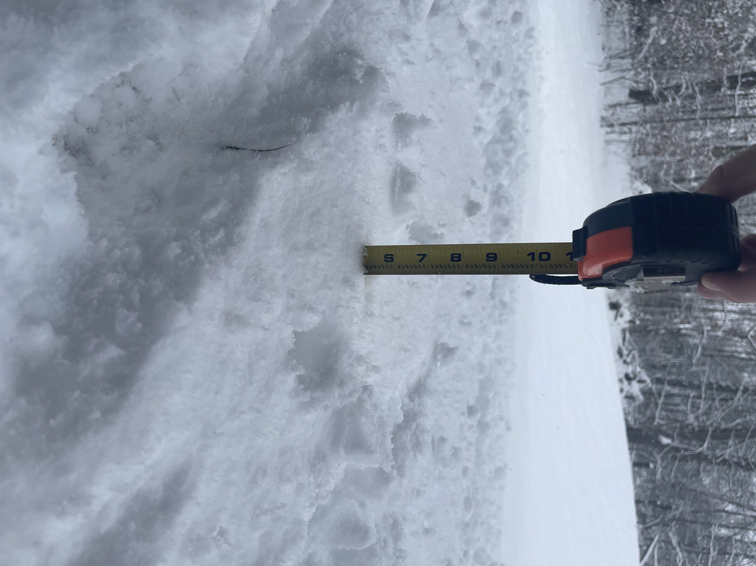
I picked up a little more while shoveling so def got 5-6" here before setting and compaction as Bgoney mentioned. QPF at CVG up to 0.53" and I don't recall any model going that high. I'd est. snowfall ratios at probably 9:1 or so.
As of 1pm at the Big 3 Sites:
CMH - 1.5"
DAY - 3.6"
CVG - 5.6"
Awesome! I'll update the contest thread at the 5pm climate report.
As of 1pm at the Big 3 Sites:
CMH - 1.5"
DAY - 3.6"
CVG - 5.6"
Awesome! I'll update the contest thread at the 5pm climate report.
Re: Sunday Wet Snow Thump 1/22/23
Some nice totals and I got a little over 4 inches so I was just a hair southeast of the better snows but not by muchtron777 wrote: ↑Sun Jan 22, 2023 1:56 pm I picked up a little more while shoveling so def got 5-6" here before setting and compaction as Bgoney mentioned. QPF at CVG up to 0.53" and I don't recall any model going that high. I'd est. snowfall ratios at probably 9:1 or so.
As of 1pm at the Big 3 Sites:
CMH - 1.5"
DAY - 3.6"
CVG - 5.6"
Awesome! I'll update the contest thread at the 5pm climate report.
Re: Sunday Wet Snow Thump 1/22/23
Driveway and sidewalks are just wet after the shoveling but the streets are a mess. Have not seen one plow back here and I know my neighbor was trying to go out this morning but could not make it up the hill on our street.
Re: Sunday Wet Snow Thump 1/22/23
Snow is heading directly into Buffalo. Should be a nice snowy game
Re: Sunday Wet Snow Thump 1/22/23
Getting one last nice band of snow moving through about 4 miles north of MGY. They are saying on the radio that Buffalo is only going to get an inch from this. I wonder if they under estimating the amount of QPF that is heading toward Buffalo??
Constant Lurker, Occasional Poster
Miami Township Southern Montgomery County
Miami Township Southern Montgomery County
Re: Sunday Wet Snow Thump 1/22/23
If you look at the Radar I believe that is underestimating the snow totals.
Re: Sunday Wet Snow Thump 1/22/23
You would think, but what do I know
Constant Lurker, Occasional Poster
Miami Township Southern Montgomery County
Miami Township Southern Montgomery County
-
tron777
- Major Hurricane
- Posts: 25387
- Joined: Fri Feb 26, 2021 5:10 pm
- Location: Burlington, KY
- Contact:
Re: Sunday Wet Snow Thump 1/22/23
Yeah, it's snowing there now. Game is going to be fun to watch! WHODEY!
-
tron777
- Major Hurricane
- Posts: 25387
- Joined: Fri Feb 26, 2021 5:10 pm
- Location: Burlington, KY
- Contact:
Re: Sunday Wet Snow Thump 1/22/23
-
weatherbeast45107
- Rain Shower
- Posts: 52
- Joined: Mon Jan 03, 2022 5:16 pm
- Location: Warren County, Ohio
Re: Sunday Wet Snow Thump 1/22/23
Measured a solid 4 earlier today near Blanchester and then got another inch or so before it stopped and started compacting.tron777 wrote: ↑Sun Jan 22, 2023 1:56 pm I picked up a little more while shoveling so def got 5-6" here before setting and compaction as Bgoney mentioned. QPF at CVG up to 0.53" and I don't recall any model going that high. I'd est. snowfall ratios at probably 9:1 or so.
As of 1pm at the Big 3 Sites:
CMH - 1.5"
DAY - 3.6"
CVG - 5.6"
Awesome! I'll update the contest thread at the 5pm climate report.
-
MVWxObserver
- Hurricane
- Posts: 6893
- Joined: Fri Feb 26, 2021 7:48 pm
- Location: Greenville, OH
Re: Sunday Wet Snow Thump 1/22/23
Just finished shoveling after taking a couple of measurements. On a place of our walkway 1.50" and then an area of the front yard at 2 to 2.50".
Eric
Greenville, OH
Greenville, OH
-
young pup
- EF4 Tornado
- Posts: 753
- Joined: Wed Mar 03, 2021 7:13 pm
- Location: Grandview ( Westside of downtown CMH)
Re: Sunday Wet Snow Thump 1/22/23
Well, 3 to 5 in areas here. I stopped working so I could watch some of the football game. Might run out here at halftime to go by a couple of smaller places.

Re: Sunday Wet Snow Thump 1/22/23
A good 4-5” here. Done shoveling!
Mike B.
Miamisburg, OH
The KING of the domes!

Miamisburg, OH
The KING of the domes!
-
tron777
- Major Hurricane
- Posts: 25387
- Joined: Fri Feb 26, 2021 5:10 pm
- Location: Burlington, KY
- Contact:
Re: Sunday Wet Snow Thump 1/22/23
Nice guys! Glad the I-70 Crew scored too!
-
tron777
- Major Hurricane
- Posts: 25387
- Joined: Fri Feb 26, 2021 5:10 pm
- Location: Burlington, KY
- Contact:
Re: Sunday Wet Snow Thump 1/22/23
As of the 5pm climate report, CVG picked up 5.6" today breaking the old daily snowfall record of 4.5" from 1966. This puts our seasonal snowfall now at 12.8" which is 2.5" above normal! At this time last year, only 2.4" had fallen.
