January 2023 Weather Discussion
-
tron777

- Major Hurricane
- Posts: 25792
- Joined: Fri Feb 26, 2021 5:10 pm
- Location: Burlington, KY
- Contact:
Re: January 2023 Weather Discussion
12Z GEFS continues to show a varying array of solutions from snow over Lower Mich, N IN / OH to dry conditions to a snow storm for folks mainly S of I-70 including Cincy and NKY. All locations are in play for this event at this early stage of the game. IT's a different set up here with a wave of low pressure along a boundary. A little overrunning with this system and some Gulf moisture getting involved IMO will make it an interesting one to track. How fast does that high in Canada lift out and how strong will it be are also critical questions with this system.

-
tron777
- Major Hurricane
- Posts: 25792
- Joined: Fri Feb 26, 2021 5:10 pm
- Location: Burlington, KY
- Contact:
Re: January 2023 Weather Discussion
12Z UKIE is going the northern route with the snow band ending at 144 hours with the wave of low pressure over S ILL.
-
tron777
- Major Hurricane
- Posts: 25792
- Joined: Fri Feb 26, 2021 5:10 pm
- Location: Burlington, KY
- Contact:
Re: January 2023 Weather Discussion
12Z GEFS as we approach mid month still looking good for a storm coming in from the SW then rolls east over us then re-develops off the SE Coast. Kind of a complex set up there. But with bigger storms, that is usually the case. Precip types with the weekend system and approaching mid month storm are all over the place from rain, ice, snow, all combo of the 3, etc. So no changes from me. I like what I see.
Re: January 2023 Weather Discussion
have to admit. especially after Christmas weekend. it kind of feels nice to have these temps in early January. got spring fever here . a nice break on the heating bill also.
22'/23' snowfall > 11"
23'/24' snowfall > 19.5"
24'/25' snowfall > 24 "
23'/24' snowfall > 19.5"
24'/25' snowfall > 24 "
-
tron777
- Major Hurricane
- Posts: 25792
- Joined: Fri Feb 26, 2021 5:10 pm
- Location: Burlington, KY
- Contact:
Re: January 2023 Weather Discussion
We have 60s here today and tomorrow before winter like temps return in the 30s / 40s. More what you'd expect for this time of year.
-
tron777
- Major Hurricane
- Posts: 25792
- Joined: Fri Feb 26, 2021 5:10 pm
- Location: Burlington, KY
- Contact:
Re: January 2023 Weather Discussion
With our current incoming system, the Euro has the heaviest action overnight thru tomorrow morning. A break then another heavy round Tues evening into the overnight hours. I still think the severe stuff stays to our SW but worth keeping that one eye open for sure. Inch plus easy looks good for most folks rainfall wise. Still liking wind gusts of 30-40 mph tomorrow esp in between rounds of rain / t-storms.
-
Bgoney

- Hurricane
- Posts: 5057
- Joined: Fri Feb 26, 2021 7:09 pm
- Location: East clermont, 3mls north of Williamsburg
Re: January 2023 Weather Discussion
Past week qpf out west is phenomenal, with at least another week of like amounts expected
You do not have the required permissions to view the files attached to this post.
Proud owner of Best Guess Forecast Center (BGFC)
Former owner of Gut Feeling Forecast (GFF) and Doppler Infinity
Former owner of Gut Feeling Forecast (GFF) and Doppler Infinity
-
tron777
- Major Hurricane
- Posts: 25792
- Joined: Fri Feb 26, 2021 5:10 pm
- Location: Burlington, KY
- Contact:
Re: January 2023 Weather Discussion
I heard on the news where Oakland, CA the other day had their wettest December Day on record with over 5" of rain and the old record was back during the Super Nino of 82. I found it. 5.01" fell on 12/31. Welcome to La Nino???
-
tron777
- Major Hurricane
- Posts: 25792
- Joined: Fri Feb 26, 2021 5:10 pm
- Location: Burlington, KY
- Contact:
Re: January 2023 Weather Discussion
For this coming weekend, the 12Z Euro is showing a wintry mix on this run for the area with all precip types possible.
-
Bgoney
- Hurricane
- Posts: 5057
- Joined: Fri Feb 26, 2021 7:09 pm
- Location: East clermont, 3mls north of Williamsburg
Re: January 2023 Weather Discussion
Had a high of 63, currently 60 , DP 55. All under thick cloud cover Jan. 2nd. Impressive!!
Proud owner of Best Guess Forecast Center (BGFC)
Former owner of Gut Feeling Forecast (GFF) and Doppler Infinity
Former owner of Gut Feeling Forecast (GFF) and Doppler Infinity
-
Bgoney
- Hurricane
- Posts: 5057
- Joined: Fri Feb 26, 2021 7:09 pm
- Location: East clermont, 3mls north of Williamsburg
Re: January 2023 Weather Discussion
A gauntlet of storms await the coast this week. Reservoir filling rains and snows galore.. To much of a good thing at once for sure but beggars can't be choosers. Surfs up!!!
You do not have the required permissions to view the files attached to this post.
Proud owner of Best Guess Forecast Center (BGFC)
Former owner of Gut Feeling Forecast (GFF) and Doppler Infinity
Former owner of Gut Feeling Forecast (GFF) and Doppler Infinity
-
tron777
- Major Hurricane
- Posts: 25792
- Joined: Fri Feb 26, 2021 5:10 pm
- Location: Burlington, KY
- Contact:
Re: January 2023 Weather Discussion
955 MB Low, wow! Very impressive! 60 here so far here today, 59 CVG.
-
MVWxObserver
- Hurricane
- Posts: 7085
- Joined: Fri Feb 26, 2021 7:48 pm
- Location: Greenville, OH
Re: January 2023 Weather Discussion
Currently 54 with a DP of 54 here in G'ville. 59 at DAY.
Eric
Greenville, OH
Greenville, OH
-
tron777
- Major Hurricane
- Posts: 25792
- Joined: Fri Feb 26, 2021 5:10 pm
- Location: Burlington, KY
- Contact:
Re: January 2023 Weather Discussion
12Z EPS showing both systems well... this weekend's and the as we approach mid month system. We of course are waiting to see what form these two will take and track so we can see where the p-types will be across the area.
Re: January 2023 Weather Discussion
Good Afternoon and made it back from SC. Of course have not looked at anything concerning the weather but will do so in the next few hours before the Bengals game.
-
tron777
- Major Hurricane
- Posts: 25792
- Joined: Fri Feb 26, 2021 5:10 pm
- Location: Burlington, KY
- Contact:
Re: January 2023 Weather Discussion
Welcome Home Tim! We've got 3 systems on the menu! Tonight thru Wed morning. This weekend, and again as we approach mid month. Get ready!
Re: January 2023 Weather Discussion
Good Evening and no doubt January is going to be very busy on the weather front. My forecast through mid-January has not changed much but the one concern I have is the NAO. Staying more positive then I like to see and after the nice system the next two days we go into a more seasonal type of weather with smaller systems and temps a few degrees either side of normal so then we need to see where these possible smaller systems track.
Can we get snow with this pattern and the answer is yes. Matter of fact since the systemS are weaker we tend to pull little in the way of warm air into the systems but also that means limited moisture. If we can stay north of any system that forms you can get a few 1-2 inch snows which living around here that is very typical.
Mid-month and beyond and when will the polar air try and return. January compared to February is somewhat different with much of Canada remaining cold but not like early December. The polar region will remain cold but the coldest compared to normal is northeast Canada. Can we pull some cold air with a few back door cold fronts and sure that is possible but they usually only go so far west before they give into milder air in the south central states plus snow pack does not look widespread so that does not help.
The coldest air in eastern Siberia and saw -67 so not too shabby. The AO does look to head somewhat negative overtime and that should help with the cold air.
Usually with a pattern change a bigger system tends to be the forerunner and that is something models will not be able to pick up well this early though you may see a run or two where they start to show a bigger storm and then nothing the next run. Not worried about that but hopefully later this week you start to see that more often.
The question when will that change come and still believe in the middle of the month and again models will show above normal temps and then one day a switch in the NAO or the mjo forecasts head more into phase 8 and 1 and you will see the models switch too a colder pattern.
Thursday of this week has a upper system that has some energy but I believe mainly snow flurries but once in awhile you could see a quick snow shower with some gusts of wind that makes it look wild for about 10-15 minutes. Could see a dusting especially on the grass with this but overall it would just look nice for a brief period.
Small system over the weekend is possible but trying to find out exactly where that piece of energy will end up trying to form a weak low pressure will probably be known by Thursday or so. Then another piece next week. Good to be back home
-
tron777
- Major Hurricane
- Posts: 25792
- Joined: Fri Feb 26, 2021 5:10 pm
- Location: Burlington, KY
- Contact:
Re: January 2023 Weather Discussion
Glad you are home Tim. We need ya! A lot of moving pieces and such. As you could tell by my posts, I am fairly interested in the weekend system. 


Re: January 2023 Weather Discussion
Good Evening Les and it was fun driving up here today as you could see the cloud banks and they were filled with moisture. Of course had fog the first two hours of driving and another indicator of moisture. I agree Les the weekend system has my interest. I would like to see a Sunday system instead of Saturday to maybe get a little more moisture involved but we have time to look at that later this week. Of course I will be watching closely where the polar air is trying to move forward and once we see that it helps in timing of any polar air headed this way. Btw Tuesday morning say between 4a-8a would not be surprised to hear some thunder and pounding rain for a few hours. Tuesday evening will probably bring another round of showers and thundershowers but that could be mainly a gusty wind issue.
-
tron777
- Major Hurricane
- Posts: 25792
- Joined: Fri Feb 26, 2021 5:10 pm
- Location: Burlington, KY
- Contact:
Re: January 2023 Weather Discussion
Lots of TOR watches out tonight Tim. Wow!tpweather wrote: ↑Mon Jan 02, 2023 7:30 pmGood Evening Les and it was fun driving up here today as you could see the cloud banks and they were filled with moisture. Of course had fog the first two hours of driving and another indicator of moisture. I agree Les the weekend system has my interest. I would like to see a Sunday system instead of Saturday to maybe get a little more moisture involved but we have time to look at that later this week. Of course I will be watching closely where the polar air is trying to move forward and once we see that it helps in timing of any polar air headed this way. Btw Tuesday morning say between 4a-8a would not be surprised to hear some thunder and pounding rain for a few hours. Tuesday evening will probably bring another round of showers and thundershowers but that could be mainly a gusty wind issue.
A bumpy 48 hours ahead for the Nation as we transition back into a more seasonal air mass. It is a balancing act with the weekend system. We need a little bit of strength for good moisture influx and need the high to be strong over Canada and for it to be in the correct position. If any piece of this is wrong, it goes bad for us. It goes bad either drier or warmer and wetter. Going to be a lot of moving and shifting IMO even as we get closer.
You do not have the required permissions to view the files attached to this post.
-
tron777
- Major Hurricane
- Posts: 25792
- Joined: Fri Feb 26, 2021 5:10 pm
- Location: Burlington, KY
- Contact:
Re: January 2023 Weather Discussion
61 at CVG today, 64 was the record from 2006. None of the Big 3 broke a record today. Tomorrow probably safe also. 67 at CVG from 2004. Might get to 65?
-
tron777
- Major Hurricane
- Posts: 25792
- Joined: Fri Feb 26, 2021 5:10 pm
- Location: Burlington, KY
- Contact:
Re: January 2023 Weather Discussion
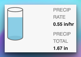
1.72" at CVG event total upcoming from the 18Z Euro. 1-2" still looking like a solid call for the region with this next system.
-
tron777
- Major Hurricane
- Posts: 25792
- Joined: Fri Feb 26, 2021 5:10 pm
- Location: Burlington, KY
- Contact:
Re: January 2023 Weather Discussion
This was posted by Meteorologist Larry Cosgrove on Weather America: (Can read it on Facebook or their Google Group):
Let us go a little more in-depth about the upcoming sudden stratospheric warming event. With an add-on of how the Madden-Julian Oscillation could be an influence in getting a winter re-start in North America in the second half of the month.
I realize with the rather boring temperature display in the USA and Canada, that any talk of an Arctic intrusion may be (mildly putting it....) triggering smirks from people enjoying the (predicted) January Thaw. But for about a week now, all four of the numerical model forecasts for the 10MB level have consistently shown a warming in the stratosphere over Russia that culminates in a (relatively) warm bubble aloft over Alaska, British Columbia and the Yukon Territory after January 15. When you see an SSW episode, look at the general flow, the position of the circumpolar vortex, and the extent of snow and ice cover. Upon doing this, you realize that a "Siberian Express" with cross-polar flow option could occur between January 15 and February 1. This configuration looks much stronger and longer-lived than the December cold surge and Great Lakes storm.
Of course things could change. But when I look at the rather inert Madden-Julian Oscillation, and see the various guidance pulsing the core to southwest of the Hawaiian Islands, and a linkage to the now disconnected polar westerlies, you can put together a "trouble brewing" scenario. I have seen similar cases of upper atmospheric disturbances and interplay, and will be looking for one of the northern stream impulses to dig through the southern tier of the U.S., then deepen as it heads up along and/off of the Eastern Seaboard. If the intensification occurs with great surface divergence and upper air convergence, the "Thaw" will leave town in a hurry.
-
Bgoney
- Hurricane
- Posts: 5057
- Joined: Fri Feb 26, 2021 7:09 pm
- Location: East clermont, 3mls north of Williamsburg
Re: January 2023 Weather Discussion
You do not have the required permissions to view the files attached to this post.
Proud owner of Best Guess Forecast Center (BGFC)
Former owner of Gut Feeling Forecast (GFF) and Doppler Infinity
Former owner of Gut Feeling Forecast (GFF) and Doppler Infinity
-
BookNerdCarp

- EF1 Tornado
- Posts: 420
- Joined: Fri Feb 26, 2021 5:57 pm
Re: January 2023 Weather Discussion
Coming down IMBY
*_*_*_*_*_*_*_*_*_*_*_*_*_*_*_*_*_*_*_*_*_*
Ripley, OH (Brown County)
Home of the "Cold Rain Haters"
*_*_*_*_*_*_*_*_*_*_*_*_*_*_*_*_*_*_*_*_*_*
Ripley, OH (Brown County)
Home of the "Cold Rain Haters"
*_*_*_*_*_*_*_*_*_*_*_*_*_*_*_*_*_*_*_*_*_*
