One - Two Sucker Punch for Next Week Feb 10-13, 2025
-
Bgoney

- Tropical Storm
- Posts: 4882
- Joined: Fri Feb 26, 2021 7:09 pm
- Location: East clermont, 3mls north of Williamsburg
Re: One - Two Sucker Punch for Next Week Feb 10-13, 2025
Just a reminder and we talked about this yesterday. Temps will be anywhere from 32-35 while it’s snowing and the amount of qpf bump we need to see to get the 3” amounts let alone 4” being talked about for cvgland
Proud owner of Best Guess Forecast Center (BGFC)
Former owner of Gut Feeling Forecast (GFF) and Doppler Infinity
Former owner of Gut Feeling Forecast (GFF) and Doppler Infinity
Re: One - Two Sucker Punch for Next Week Feb 10-13, 2025
Great point Bgoney. No doubt a very wet snow and really you will see these big fat flakes and sometimes when they hit the pavement they are just like a water balloon and splatter. They tend to accumulate more on trees and the grass than pavement. Of course if you get a nice couple of hours with the higher rates they will finally accumulate especially if its not during the 10a-2pm peak sun. This is the kind of system where you may get say 0.25 of precip and even have a couple of inches on the ground but if the snow lets up it can dissipate quickly.
-
tron777

- Major Hurricane
- Posts: 24965
- Joined: Fri Feb 26, 2021 5:10 pm
- Location: Burlington, KY
- Contact:
Re: One - Two Sucker Punch for Next Week Feb 10-13, 2025
12Z HRRR has a couple of inches at CVG.

-
tron777
- Major Hurricane
- Posts: 24965
- Joined: Fri Feb 26, 2021 5:10 pm
- Location: Burlington, KY
- Contact:
Re: One - Two Sucker Punch for Next Week Feb 10-13, 2025
3.47" on the mean from the 9Z SREF. Wow....
Re: One - Two Sucker Punch for Next Week Feb 10-13, 2025
Les about ready to post the latest. No doubt has been inching up since Sunday morning. I know a lot of the talk has been the heaviest snow along the I-64 area but I have it slightly north of that area and again I still like the Dry Ridge to Georgetown,Ky area with the best chance of getting the highest totals.
-
tron777
- Major Hurricane
- Posts: 24965
- Joined: Fri Feb 26, 2021 5:10 pm
- Location: Burlington, KY
- Contact:
Re: One - Two Sucker Punch for Next Week Feb 10-13, 2025
So far Tim, that looks like a nice call! I think a band of 3-5" will be likely across our far south / northern LOU's forecast area as well. If we can get an inch or two in our hoods, I would consider it a win.tpweather wrote: ↑Mon Feb 10, 2025 8:50 amLes about ready to post the latest. No doubt has been inching up since Sunday morning. I know a lot of the talk has been the heaviest snow along the I-64 area but I have it slightly north of that area and again I still like the Dry Ridge to Georgetown,Ky area with the best chance of getting the highest totals.
-
tron777
- Major Hurricane
- Posts: 24965
- Joined: Fri Feb 26, 2021 5:10 pm
- Location: Burlington, KY
- Contact:
Re: One - Two Sucker Punch for Next Week Feb 10-13, 2025
12Z NAM continues to be juiced up giving CVG 0.33" of QPF.
-
Bgoney
- Tropical Storm
- Posts: 4882
- Joined: Fri Feb 26, 2021 7:09 pm
- Location: East clermont, 3mls north of Williamsburg
Re: One - Two Sucker Punch for Next Week Feb 10-13, 2025
NAM gives Cvg 3” by 1pm
Proud owner of Best Guess Forecast Center (BGFC)
Former owner of Gut Feeling Forecast (GFF) and Doppler Infinity
Former owner of Gut Feeling Forecast (GFF) and Doppler Infinity
-
tron777
- Major Hurricane
- Posts: 24965
- Joined: Fri Feb 26, 2021 5:10 pm
- Location: Burlington, KY
- Contact:
Re: One - Two Sucker Punch for Next Week Feb 10-13, 2025
12Z RGEM is coming inline with most models. Up to an inch NW of I-71, 2" along and slightly SE then 3-4"+ in our S counties.
-
tron777
- Major Hurricane
- Posts: 24965
- Joined: Fri Feb 26, 2021 5:10 pm
- Location: Burlington, KY
- Contact:
Re: One - Two Sucker Punch for Next Week Feb 10-13, 2025
12Z GFS ticked south again from the 6Z run. But in all fairness, this model has been one of the furthest south solutions all along.
Re: One - Two Sucker Punch for Next Week Feb 10-13, 2025
Brian had a great video and explained everything we have been talking about all weekend. He mentioned now cast and no doubt with this kind of system as we wait later today and see exactly where everything is shaping up. Then we can sort of move the needle either way. He explained the longer term somewhat but sure he will get into that more on Wednesday. Sticking with the forecast from Bgoney yesterday and thought it really looked good if we need to adjust here and there we can. If you end up with one of the heavier bands for a few hours then you can get some of those higher totals but placement not perfect at this moment.
-
Bgoney
- Tropical Storm
- Posts: 4882
- Joined: Fri Feb 26, 2021 7:09 pm
- Location: East clermont, 3mls north of Williamsburg
Re: One - Two Sucker Punch for Next Week Feb 10-13, 2025
All the global models have come together to fit the forecast , just hope there’s no more trend south
Proud owner of Best Guess Forecast Center (BGFC)
Former owner of Gut Feeling Forecast (GFF) and Doppler Infinity
Former owner of Gut Feeling Forecast (GFF) and Doppler Infinity
-
BookNerdCarp

- EF1 Tornado
- Posts: 413
- Joined: Fri Feb 26, 2021 5:57 pm
Re: One - Two Sucker Punch for Next Week Feb 10-13, 2025
So close I can smell the air on that one....just the river dividing me LOL
KYZ098>100-110300-
/O.UPG.KILN.WS.A.0003.250211T0900Z-250212T1200Z/
/O.NEW.KILN.WS.W.0002.250211T0900Z-250212T1200Z/
Robertson-Mason-Lewis-
Including the cities of Camp Dix, Vanceburg, Head Of Grassy,
Tollesboro, Mount Olivet, and Maysville
1255 PM EST Mon Feb 10 2025
...WINTER STORM WARNING IN EFFECT FROM 4 AM TUESDAY TO 7 AM EST
WEDNESDAY...
* WHAT...Heavy snow expected. Total snow accumulations between 4 and
5 inches.
* WHERE...Lewis, Mason, and Robertson Counties.
* WHEN...From 4 AM Tuesday to 7 AM EST Wednesday.
* IMPACTS...Travel conditions will likely become very difficult.
Travel could be very difficult. The hazardous conditions could
impact the Tuesday morning and evening commutes.
PRECAUTIONARY/PREPAREDNESS ACTIONS...
If you must travel, keep an extra flashlight, food, and water in
your vehicle in case of an emergency. visit goky.ky.gov for the
latest road information.
*_*_*_*_*_*_*_*_*_*_*_*_*_*_*_*_*_*_*_*_*_*
Ripley, OH (Brown County)
Home of the "Cold Rain Haters"
*_*_*_*_*_*_*_*_*_*_*_*_*_*_*_*_*_*_*_*_*_*
Ripley, OH (Brown County)
Home of the "Cold Rain Haters"
*_*_*_*_*_*_*_*_*_*_*_*_*_*_*_*_*_*_*_*_*_*
-
tron777
- Major Hurricane
- Posts: 24965
- Joined: Fri Feb 26, 2021 5:10 pm
- Location: Burlington, KY
- Contact:
Re: One - Two Sucker Punch for Next Week Feb 10-13, 2025
0.23" from the 12Z Euro at CVG.
-
tron777
- Major Hurricane
- Posts: 24965
- Joined: Fri Feb 26, 2021 5:10 pm
- Location: Burlington, KY
- Contact:
Re: One - Two Sucker Punch for Next Week Feb 10-13, 2025
You should get 3"+ in my opinion.BookNerdCarp wrote: ↑Mon Feb 10, 2025 1:04 pm So close I can smell the air on that one....just the river dividing me LOL
-
tron777
- Major Hurricane
- Posts: 24965
- Joined: Fri Feb 26, 2021 5:10 pm
- Location: Burlington, KY
- Contact:
Re: One - Two Sucker Punch for Next Week Feb 10-13, 2025
Counties S of the Metro have also been upgraded to a warning.
Owen-Grant-Pendleton-Bracken-Adams-Scioto-
Including the cities of Crittenden, Manchester, Seaman, Butler,
Portsmouth, West Union, Dry Ridge, Winchester, Williamstown,
Falmouth, Brooksville, Augusta, Peebles, Owenton, and
Wheelersburg
1255 PM EST Mon Feb 10 2025
...WINTER STORM WARNING IN EFFECT FROM 4 AM TUESDAY TO 7 AM EST
WEDNESDAY...
* WHAT...Heavy snow expected. Total snow accumulations between 3 and
4 inches.
* WHERE...In Kentucky, Bracken, Grant, Owen, and Pendleton Counties.
In Ohio, Adams and Scioto Counties.
* WHEN...From 4 AM Tuesday to 7 AM EST Wednesday.
* IMPACTS...Travel conditions will likely become very difficult.
Plan on slippery road conditions. The hazardous conditions could
impact the Tuesday morning and evening commutes.
-
BookNerdCarp
- EF1 Tornado
- Posts: 413
- Joined: Fri Feb 26, 2021 5:57 pm
Re: One - Two Sucker Punch for Next Week Feb 10-13, 2025
Les, what's your opinion on Georgetown? About the same?tron777 wrote: ↑Mon Feb 10, 2025 1:06 pmYou should get 3"+ in my opinion.BookNerdCarp wrote: ↑Mon Feb 10, 2025 1:04 pm So close I can smell the air on that one....just the river dividing me LOL
*_*_*_*_*_*_*_*_*_*_*_*_*_*_*_*_*_*_*_*_*_*
Ripley, OH (Brown County)
Home of the "Cold Rain Haters"
*_*_*_*_*_*_*_*_*_*_*_*_*_*_*_*_*_*_*_*_*_*
Ripley, OH (Brown County)
Home of the "Cold Rain Haters"
*_*_*_*_*_*_*_*_*_*_*_*_*_*_*_*_*_*_*_*_*_*
-
tron777
- Major Hurricane
- Posts: 24965
- Joined: Fri Feb 26, 2021 5:10 pm
- Location: Burlington, KY
- Contact:
Re: One - Two Sucker Punch for Next Week Feb 10-13, 2025
Should be similar, yeah.BookNerdCarp wrote: ↑Mon Feb 10, 2025 1:13 pmLes, what's your opinion on Georgetown? About the same?tron777 wrote: ↑Mon Feb 10, 2025 1:06 pmYou should get 3"+ in my opinion.BookNerdCarp wrote: ↑Mon Feb 10, 2025 1:04 pm So close I can smell the air on that one....just the river dividing me LOL
-
tron777
- Major Hurricane
- Posts: 24965
- Joined: Fri Feb 26, 2021 5:10 pm
- Location: Burlington, KY
- Contact:
Re: One - Two Sucker Punch for Next Week Feb 10-13, 2025
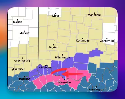
I really haven't seen much change in todays guidance. The same models that are juiced up and north continue to be (NAM and SREF) with the furthest south model being the GFS, CMC and Euro are in between. A 1-3" call (lowest north of the river, highest as one goes south) is still a good call. South of the Metro are where the heaviest totals will be found in that 3"+ variety. I think ILN is handling this event correctly.
-
BookNerdCarp
- EF1 Tornado
- Posts: 413
- Joined: Fri Feb 26, 2021 5:57 pm
Re: One - Two Sucker Punch for Next Week Feb 10-13, 2025
I have always found this humorous in Warning outlines. I know they go by county, but....if you connect the dots 
I have resorted to begging ......
I have resorted to begging ......
*_*_*_*_*_*_*_*_*_*_*_*_*_*_*_*_*_*_*_*_*_*
Ripley, OH (Brown County)
Home of the "Cold Rain Haters"
*_*_*_*_*_*_*_*_*_*_*_*_*_*_*_*_*_*_*_*_*_*
Ripley, OH (Brown County)
Home of the "Cold Rain Haters"
*_*_*_*_*_*_*_*_*_*_*_*_*_*_*_*_*_*_*_*_*_*
Re: One - Two Sucker Punch for Next Week Feb 10-13, 2025
The southern part of Brown County should get more snow than the northern part of Adams County. Lol! Enjoy the snow! Warning, Advisory, or nothing issued you will see the same amount of snow regardless.BookNerdCarp wrote: ↑Mon Feb 10, 2025 1:19 pm I have always found this humorous in Warning outlines. I know they go by county, but....if you connect the dots
I have resorted to begging ......
I had a 5 1/2" storm in Montgomery county a few years back and not even an advisory was issued. I enjoyed it all the same!
Doug
Huber Heights
Huber Heights
-
tron777
- Major Hurricane
- Posts: 24965
- Joined: Fri Feb 26, 2021 5:10 pm
- Location: Burlington, KY
- Contact:
Re: One - Two Sucker Punch for Next Week Feb 10-13, 2025
0.26" at CVG from the 18Z NAM. It is finally coming back to earth. 15Z SREF has a mean of 2.31" at CVG so it is also slowly coming back down to reality. 18Z RGEM still has a 1-3" snowfall from around Cincy and points S and SE. Lighter NW, heaviest SE. The cut off as we have been saying will be brutal. Some of you on this forum won't see a single flake out of this system.
For the next one, late Wed into early Thurs, still expecting mainly rain from it, could end as some flakes on Thurs. Not a big deal from a wintry perspective.
For the next one, late Wed into early Thurs, still expecting mainly rain from it, could end as some flakes on Thurs. Not a big deal from a wintry perspective.
-
tron777
- Major Hurricane
- Posts: 24965
- Joined: Fri Feb 26, 2021 5:10 pm
- Location: Burlington, KY
- Contact:
Re: One - Two Sucker Punch for Next Week Feb 10-13, 2025
18Z GFS is up to 0.19" for QPF so it is finally joining the rest of the guidance. A blend of all models yields 0.20" at CVG for QPF. 2" of snow at a 10:1 ratio so a call of 1-2" is perfect.
-
tron777
- Major Hurricane
- Posts: 24965
- Joined: Fri Feb 26, 2021 5:10 pm
- Location: Burlington, KY
- Contact:
Re: One - Two Sucker Punch for Next Week Feb 10-13, 2025
Per SPC mesopage, the baroclinic boundary is lying over Middle TN at this time. Starting to see some -EPV and 700 MB frontogenic forcing over the Tri-state. Moisture return is also ongoing in the mid and upper levels from the Gulf of America. Some snow is filling in now (probably virga at the early stages) over Northern MO and Central ILL. Showers are increasing over AR, TN, OK, TX, and S MO. We should continue to see the radar blossom with precip tonight. Good sign seeing snow, even if it is virga right now, mainly N of St. Louis.
